|
|
|||||||||||||||||
| Point ID: 8135 | Downloads | Plots | Site Data | Code: 1803 |
|
|
|||||||||||||||||
| Download | |
|---|---|
| Site Descriptor Information | Site Time Series Data |
| Link to all available data | |
|
|
| View: | Statistics | Time Series |
| Units: | mm |
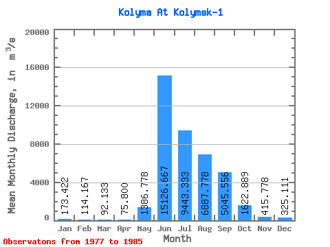
| Statistic | Jan | Feb | Mar | Apr | May | Jun | Jul | Aug | Sep | Oct | Nov | Dec | Annual |
|---|---|---|---|---|---|---|---|---|---|---|---|---|---|
| Mean | 173.42 | 114.17 | 92.13 | 75.80 | 1386.78 | 15126.67 | 9443.33 | 6887.78 | 5045.56 | 1622.89 | 415.78 | 325.11 | 3392.45 |
| Standard Deviation | 65.95 | 43.24 | 41.20 | 34.55 | 1200.38 | 6100.00 | 4943.38 | 1721.06 | 1850.89 | 501.97 | 112.34 | 102.25 | 940.19 |
| Min | 74.80 | 58.40 | 43.10 | 30.60 | 305.00 | 7390.00 | 3380.00 | 4230.00 | 3000.00 | 926.00 | 294.00 | 198.00 | 1871.33 |
| Max | 278.00 | 177.00 | 163.00 | 139.00 | 3670.00 | 26200.00 | 17600.00 | 9020.00 | 8760.00 | 2610.00 | 602.00 | 515.00 | 4852.75 |
| Coefficient of Variation | 0.38 | 0.38 | 0.45 | 0.46 | 0.87 | 0.40 | 0.52 | 0.25 | 0.37 | 0.31 | 0.27 | 0.32 | 0.28 |
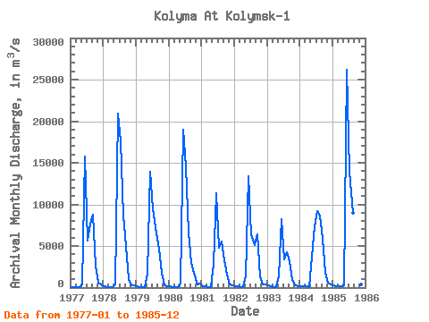
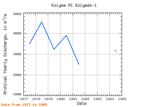
| Year | Jan | Feb | Mar | Apr | May | Jun | Jul | Aug | Sep | Oct | Nov | Dec | Annual | 1977 | 74.80 | 68.70 | 62.40 | 50.10 | 328.00 | 15800.00 | 5620.00 | 7670.00 | 8760.00 | 2610.00 | 602.00 | 378.00 | 3502.00 | 1978 | 200.00 | 84.00 | 66.00 | 51.70 | 402.00 | 20900.00 | 17600.00 | 8690.00 | 4960.00 | 1040.00 | 318.00 | 237.00 | 4545.73 | 1979 | 154.00 | 58.40 | 43.10 | 30.60 | 1690.00 | 13900.00 | 9530.00 | 6500.00 | 4630.00 | 1790.00 | 294.00 | 198.00 | 3234.84 | 1980 | 144.00 | 84.40 | 67.90 | 43.20 | 516.00 | 19000.00 | 14600.00 | 6640.00 | 3000.00 | 1730.00 | 417.00 | 515.00 | 3896.46 | 1981 | 136.00 | 130.00 | 76.50 | 100.00 | 2870.00 | 11300.00 | 4750.00 | 5540.00 | 3270.00 | 1530.00 | 383.00 | 287.00 | 2531.04 | 1982 | 181.00 | 110.00 | 93.30 | 81.90 | 1360.00 | 13400.00 | 6440.00 | 5090.00 | 6360.00 | 1330.00 | 369.00 | 390.00 | 2933.77 | 1983 | 278.00 | 155.00 | 105.00 | 91.00 | 1340.00 | 8250.00 | 3380.00 | 4230.00 | 3150.00 | 926.00 | 340.00 | 211.00 | 1871.33 | 1984 | 127.00 | 160.00 | 152.00 | 94.70 | 3670.00 | 7390.00 | 9170.00 | 8610.00 | 5820.00 | 1810.00 | 597.00 | 369.00 | 3164.14 | 1985 | 266.00 | 177.00 | 163.00 | 139.00 | 305.00 | 26200.00 | 13900.00 | 9020.00 | 5460.00 | 1840.00 | 422.00 | 341.00 | 4852.75 |
|---|
 Return to R-Arctic Net Home Page