|
|
|||||||||||||||||
| Point ID: 8121 | Downloads | Plots | Site Data | Code: 1602 |
|
|
|||||||||||||||||
| Download | |
|---|---|
| Site Descriptor Information | Site Time Series Data |
| Link to all available data | |
| View: | Time Series | All |
| Units: | m3/s |
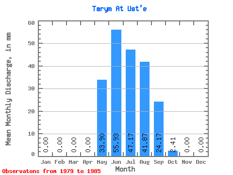
| Statistic | Jan | Feb | Mar | Apr | May | Jun | Jul | Aug | Sep | Oct | Nov | Dec | Annual |
|---|---|---|---|---|---|---|---|---|---|---|---|---|---|
| Mean | 0.00 | 0.00 | 0.00 | 0.00 | 33.87 | 55.88 | 47.22 | 41.89 | 24.15 | 2.35 | 0.00 | 0.00 | 204.28 |
| Standard Deviation | 0.00 | 0.00 | 0.00 | 0.00 | 12.52 | 44.16 | 25.53 | 16.33 | 21.05 | 1.86 | 0.00 | 0.00 | 49.60 |
| Min | 0.00 | 0.00 | 0.00 | 0.00 | 7.79 | 18.68 | 21.71 | 24.13 | 8.17 | 1.09 | 0.00 | 0.00 | 140.22 |
| Max | 0.00 | 0.00 | 0.00 | 0.00 | 42.22 | 144.78 | 84.44 | 62.80 | 70.05 | 6.39 | 0.00 | 0.00 | 266.51 |
| Coefficient of Variation | 0.37 | 0.79 | 0.54 | 0.39 | 0.87 | 0.79 | 0.24 |
 Return to R-Arctic Net Home Page