|
|
|||||||||||||||||
| Point ID: 8086 | Downloads | Plots | Site Data | Code: 1508 |
|
|
|||||||||||||||||
| Download | |
|---|---|
| Site Descriptor Information | Site Time Series Data |
| Link to all available data | |
|
|
| View: | Statistics | Time Series |
| Units: | mm |
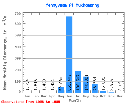
| Statistic | Jan | Feb | Mar | Apr | May | Jun | Jul | Aug | Sep | Oct | Nov | Dec | Annual |
|---|---|---|---|---|---|---|---|---|---|---|---|---|---|
| Mean | 1.75 | 1.52 | 1.43 | 1.42 | 52.08 | 663.41 | 186.51 | 140.92 | 76.96 | 15.03 | 2.98 | 2.09 | 95.95 |
| Standard Deviation | 0.35 | 0.38 | 0.45 | 0.53 | 97.13 | 255.72 | 112.45 | 67.93 | 48.55 | 18.26 | 1.02 | 0.43 | 24.78 |
| Min | 1.14 | 0.92 | 0.55 | 0.42 | 1.84 | 219.00 | 59.10 | 41.40 | 15.30 | 2.56 | 1.27 | 1.14 | 58.62 |
| Max | 2.62 | 2.76 | 2.90 | 2.76 | 497.00 | 1220.00 | 468.00 | 282.00 | 220.00 | 102.00 | 5.83 | 2.98 | 149.66 |
| Coefficient of Variation | 0.20 | 0.25 | 0.31 | 0.37 | 1.86 | 0.39 | 0.60 | 0.48 | 0.63 | 1.22 | 0.34 | 0.20 | 0.26 |
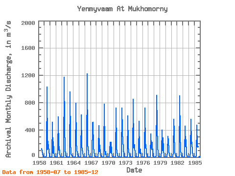
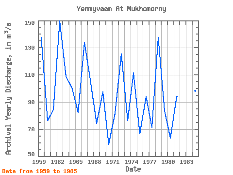
| Year | Jan | Feb | Mar | Apr | May | Jun | Jul | Aug | Sep | Oct | Nov | Dec | Annual | 1958 | 128.00 | 83.50 | 55.70 | 7.37 | 2.86 | 2.32 | 1959 | 1.91 | 1.81 | 1.67 | 1.63 | 19.60 | 1030.00 | 114.00 | 235.00 | 135.00 | 102.00 | 4.97 | 2.20 | 137.48 | 1960 | 1.79 | 2.76 | 2.90 | 1.50 | 2.56 | 510.00 | 59.10 | 224.00 | 81.40 | 21.50 | 4.11 | 2.37 | 76.17 | 1961 | 2.08 | 1.81 | 1.98 | 1.86 | 88.20 | 590.00 | 102.00 | 155.00 | 52.50 | 10.90 | 3.55 | 2.15 | 84.34 | 1962 | 1.48 | 1.41 | 1.34 | 1.27 | 1.87 | 1170.00 | 458.00 | 119.00 | 32.80 | 5.72 | 1.90 | 1.14 | 149.66 | 1963 | 1.14 | 1.12 | 1.02 | 1.03 | 2.26 | 958.00 | 237.00 | 49.40 | 29.70 | 18.10 | 2.98 | 1.98 | 108.64 | 1964 | 1.63 | 1.55 | 1.55 | 1.07 | 1.90 | 793.00 | 218.00 | 114.00 | 62.40 | 8.05 | 1.95 | 1.50 | 100.55 | 1965 | 1.23 | 1.21 | 1.26 | 1.24 | 3.20 | 622.00 | 172.00 | 103.00 | 78.20 | 3.68 | 1.87 | 1.85 | 82.56 | 1966 | 1.60 | 1.24 | 1.21 | 1.16 | 2.22 | 1220.00 | 168.00 | 149.00 | 51.90 | 9.29 | 2.71 | 1.92 | 134.19 | 1967 | 1.81 | 1.79 | 1.80 | 1.86 | 497.00 | 516.00 | 138.00 | 87.10 | 15.30 | 11.90 | 2.50 | 1.77 | 106.40 | 1968 | 1.50 | 1.17 | 1.46 | 2.76 | 96.30 | 464.00 | 80.20 | 177.00 | 56.30 | 5.22 | 2.90 | 1.75 | 74.21 | 1969 | 1.47 | 1.22 | 1.01 | 0.98 | 120.00 | 778.00 | 127.00 | 41.40 | 84.00 | 10.10 | 2.49 | 2.13 | 97.48 | 1970 | 1.97 | 1.48 | 1.39 | 1.64 | 90.10 | 219.00 | 68.30 | 220.00 | 71.90 | 21.10 | 3.94 | 2.61 | 58.62 | 1971 | 2.18 | 1.89 | 1.78 | 1.93 | 2.62 | 722.00 | 131.00 | 77.00 | 28.70 | 8.02 | 2.32 | 2.07 | 81.79 | 1972 | 1.69 | 1.48 | 1.63 | 2.30 | 3.96 | 724.00 | 384.00 | 219.00 | 150.00 | 9.69 | 4.60 | 2.14 | 125.38 | 1973 | 1.19 | 1.01 | 0.90 | 0.81 | 1.84 | 604.00 | 174.00 | 69.10 | 59.10 | 2.56 | 1.27 | 1.25 | 76.42 | 1974 | 1.36 | 0.92 | 0.55 | 0.42 | 6.67 | 852.00 | 141.00 | 135.00 | 180.00 | 17.90 | 1.80 | 1.49 | 111.59 | 1975 | 1.55 | 1.38 | 1.10 | 1.24 | 14.20 | 526.00 | 71.40 | 51.90 | 115.00 | 10.20 | 2.56 | 1.89 | 66.53 | 1976 | 1.66 | 1.47 | 1.32 | 1.32 | 1.84 | 723.00 | 130.00 | 186.00 | 67.70 | 8.61 | 2.39 | 2.02 | 93.94 | 1977 | 1.59 | 1.14 | 1.08 | 1.14 | 11.30 | 342.00 | 139.00 | 108.00 | 220.00 | 25.00 | 3.71 | 2.98 | 71.41 | 1978 | 2.28 | 1.74 | 1.65 | 0.62 | 27.30 | 909.00 | 468.00 | 149.00 | 67.80 | 18.60 | 3.36 | 2.53 | 137.66 | 1979 | 2.11 | 1.52 | 1.28 | 1.34 | 86.10 | 398.00 | 95.20 | 282.00 | 120.00 | 10.40 | 3.04 | 2.42 | 83.62 | 1980 | 2.03 | 1.56 | 1.57 | 1.51 | 76.80 | 305.00 | 233.00 | 101.00 | 24.60 | 8.22 | 2.56 | 1.99 | 63.32 | 1981 | 1.77 | 1.53 | 1.44 | 1.50 | 76.60 | 555.00 | 356.00 | 74.40 | 40.80 | 12.60 | 2.86 | 2.19 | 93.89 | 1982 | 2.62 | 2.20 | 2.01 | 2.44 | 2.31 | 903.00 | 317.00 | 102.00 | 41.60 | 10.50 | 3.05 | 2.50 | 115.94 | 1983 | 2.09 | 1.60 | 1.34 | 1.40 | 56.60 | 457.00 | 154.00 | 257.00 | 45.20 | 5.23 | 2.17 | 2.24 | 82.16 | 1984 | 1.91 | 1.52 | 1.31 | 1.27 | 84.90 | 554.00 | 199.00 | 220.00 | 78.40 | 29.40 | 5.83 | 2.42 | 98.33 | 1985 | 1.72 | 1.40 | 1.05 | 1.12 | 27.90 | 468.00 | 160.00 | 157.00 | 109.00 | 9.00 | 3.08 | 2.73 | 78.50 |
|---|
 Return to R-Arctic Net Home Page