|
|
|||||||||||||||||
| Point ID: 8082 | Downloads | Plots | Site Data | Code: 1490 |
|
|
|||||||||||||||||
| Download | |
|---|---|
| Site Descriptor Information | Site Time Series Data |
| Link to all available data | |
| View: | Time Series | All |
| Units: | m3/s |
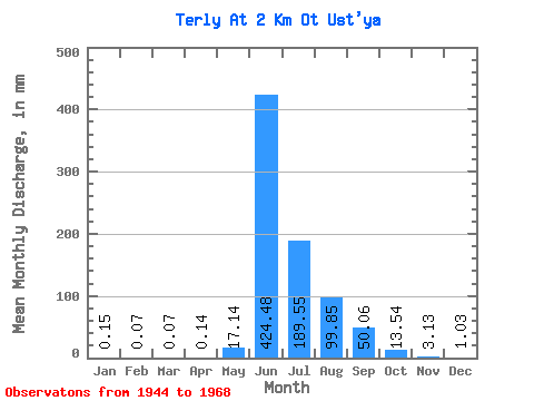
| Statistic | Jan | Feb | Mar | Apr | May | Jun | Jul | Aug | Sep | Oct | Nov | Dec | Annual |
|---|---|---|---|---|---|---|---|---|---|---|---|---|---|
| Mean | 0.18 | 0.10 | 0.11 | 0.11 | 17.13 | 424.44 | 189.49 | 99.84 | 50.06 | 13.54 | 3.11 | 1.00 | 800.36 |
| Standard Deviation | 0.49 | 0.39 | 0.48 | 0.49 | 42.08 | 182.76 | 139.85 | 39.83 | 30.79 | 12.43 | 3.20 | 1.23 | 235.28 |
| Min | 0.00 | 0.00 | 0.00 | 0.00 | 0.00 | 145.98 | 65.48 | 26.49 | 12.82 | 1.47 | 0.00 | 0.00 | 354.53 |
| Max | 1.69 | 1.74 | 2.13 | 2.21 | 167.79 | 918.59 | 660.67 | 201.59 | 131.02 | 52.24 | 10.68 | 3.53 | 1401.07 |
| Coefficient of Variation | 2.74 | 4.01 | 4.47 | 4.47 | 2.46 | 0.43 | 0.74 | 0.40 | 0.61 | 0.92 | 1.03 | 1.24 | 0.29 |
 Return to R-Arctic Net Home Page