|
|
|||||||||||||||||
| Point ID: 8058 | Downloads | Plots | Site Data | Code: 1260 |
|
|
|||||||||||||||||
| Download | |
|---|---|
| Site Descriptor Information | Site Time Series Data |
| Link to all available data | |
|
|
| View: | Statistics | Time Series |
| Units: | mm |
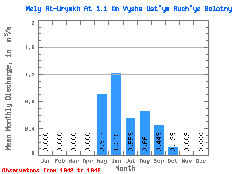
| Statistic | Jan | Feb | Mar | Apr | May | Jun | Jul | Aug | Sep | Oct | Nov | Dec | Annual |
|---|---|---|---|---|---|---|---|---|---|---|---|---|---|
| Mean | 0.00 | 0.00 | 0.00 | 0.00 | 0.92 | 1.22 | 0.56 | 0.66 | 0.45 | 0.13 | 0.00 | 0.00 | 0.33 |
| Standard Deviation | 0.00 | 0.00 | 0.00 | 0.00 | 0.53 | 1.14 | 0.11 | 0.23 | 0.28 | 0.16 | 0.01 | 0.00 | 0.09 |
| Min | 0.00 | 0.00 | 0.00 | 0.00 | 0.02 | 0.42 | 0.40 | 0.35 | 0.23 | 0.02 | 0.00 | 0.00 | 0.18 |
| Max | 0.00 | 0.00 | 0.00 | 0.00 | 1.52 | 3.89 | 0.74 | 1.03 | 0.96 | 0.50 | 0.01 | 0.00 | 0.43 |
| Coefficient of Variation | 0.57 | 0.94 | 0.20 | 0.34 | 0.61 | 1.26 | 1.56 | 2.83 | 0.28 |
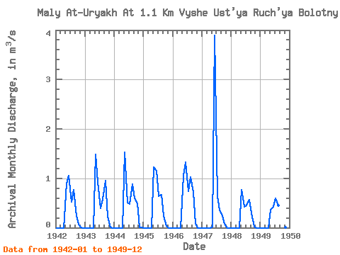
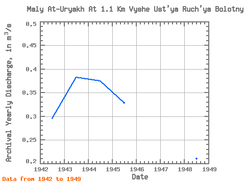
| Year | Jan | Feb | Mar | Apr | May | Jun | Jul | Aug | Sep | Oct | Nov | Dec | Annual | 1942 | 0.00 | 0.00 | 0.00 | 0.00 | 0.89 | 1.06 | 0.53 | 0.77 | 0.23 | 0.06 | 0.00 | 0.00 | 0.29 | 1943 | 0.00 | 0.00 | 0.00 | 0.00 | 1.49 | 0.92 | 0.40 | 0.58 | 0.96 | 0.22 | 0.01 | 0.00 | 0.38 | 1944 | 0.00 | 0.00 | 0.00 | 0.00 | 1.52 | 0.51 | 0.48 | 0.88 | 0.59 | 0.50 | 0.01 | 0.00 | 0.38 | 1945 | 0.00 | 0.00 | 0.00 | 0.00 | 1.22 | 1.16 | 0.64 | 0.67 | 0.23 | 0.03 | 0.00 | 0.00 | 0.33 | 1946 | 0.00 | 0.00 | 0.00 | 0.00 | 1.06 | 1.33 | 0.74 | 1.03 | 0.72 | 0.08 | 0.00 | 0.00 | 0.41 | 1947 | 0.00 | 0.00 | 0.00 | 0.00 | 0.02 | 3.89 | 0.64 | 0.35 | 0.24 | 0.07 | 0.00 | 0.00 | 0.43 | 1948 | 0.00 | 0.00 | 0.00 | 0.00 | 0.77 | 0.43 | 0.45 | 0.56 | 0.29 | 0.02 | 0.00 | 0.00 | 0.21 | 1949 | 0.00 | 0.00 | 0.00 | 0.00 | 0.37 | 0.42 | 0.59 | 0.45 | 0.33 | 0.04 | 0.00 | 0.00 | 0.18 |
|---|
 Return to R-Arctic Net Home Page