|
|
|||||||||||||||||
| Point ID: 8051 | Downloads | Plots | Site Data | Code: 1162 |
|
|
|||||||||||||||||
| Download | |
|---|---|
| Site Descriptor Information | Site Time Series Data |
| Link to all available data | |
| View: | Time Series | All |
| Units: | m3/s |
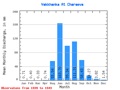
| Statistic | Jan | Feb | Mar | Apr | May | Jun | Jul | Aug | Sep | Oct | Nov | Dec | Annual |
|---|---|---|---|---|---|---|---|---|---|---|---|---|---|
| Mean | 0.72 | 0.40 | 0.35 | 0.74 | 55.54 | 163.70 | 99.33 | 111.29 | 58.43 | 14.27 | 3.83 | 1.54 | 508.42 |
| Standard Deviation | 0.46 | 0.41 | 0.36 | 0.53 | 27.57 | 58.29 | 26.75 | 28.23 | 31.89 | 4.72 | 0.91 | 0.68 | 94.45 |
| Min | 0.00 | 0.00 | 0.00 | 0.16 | 28.54 | 95.08 | 67.50 | 85.06 | 19.65 | 7.68 | 2.81 | 0.55 | 343.89 |
| Max | 1.13 | 1.00 | 0.82 | 1.43 | 93.29 | 227.86 | 127.86 | 156.95 | 95.61 | 18.66 | 4.78 | 2.23 | 580.76 |
| Coefficient of Variation | 0.63 | 1.01 | 1.04 | 0.72 | 0.50 | 0.36 | 0.27 | 0.25 | 0.55 | 0.33 | 0.24 | 0.44 | 0.19 |
 Return to R-Arctic Net Home Page