|
|
|||||||||||||||||
| Point ID: 8010 | Downloads | Plots | Site Data | Code: 3830 |
|
|
|||||||||||||||||
| Download | |
|---|---|
| Site Descriptor Information | Site Time Series Data |
| Link to all available data | |
|
|
| View: | Statistics | Time Series |
| Units: | mm |
| Statistic | Jan | Feb | Mar | Apr | May | Jun | Jul | Aug | Sep | Oct | Nov | Dec | Annual |
|---|---|---|---|---|---|---|---|---|---|---|---|---|---|
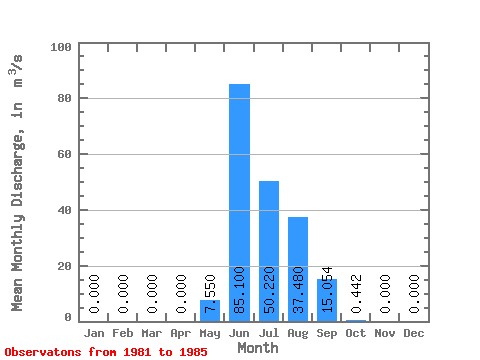
| Mean | 0.00 | 0.00 | 0.00 | 0.00 | 7.55 | 85.10 | 50.22 | 37.48 | 15.05 | 0.44 | 0.00 | 0.00 | 16.32 |
| Standard Deviation | 0.00 | 0.00 | 0.00 | 0.00 | 16.52 | 26.37 | 28.59 | 15.75 | 6.36 | 0.42 | 0.00 | 0.00 | 5.03 |
| Min | 0.00 | 0.00 | 0.00 | 0.00 | 0.00 | 62.20 | 21.40 | 14.00 | 8.47 | 0.01 | 0.00 | 0.00 | 11.60 |
| Max | 0.00 | 0.00 | 0.00 | 0.00 | 37.10 | 127.00 | 88.90 | 54.30 | 24.00 | 1.04 | 0.00 | 0.00 | 24.57 |
| Coefficient of Variation | 2.19 | 0.31 | 0.57 | 0.42 | 0.42 | 0.95 | 0.31 |
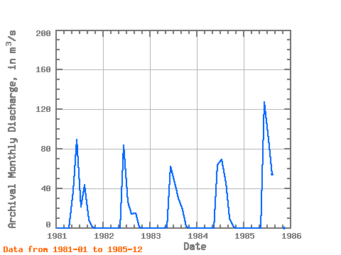
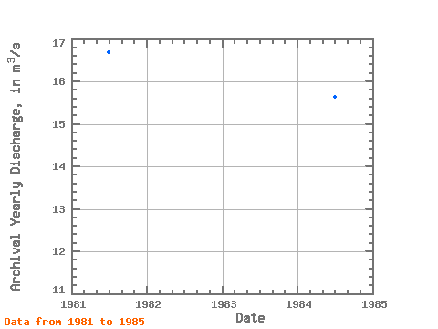
| Year | Jan | Feb | Mar | Apr | May | Jun | Jul | Aug | Sep | Oct | Nov | Dec | Annual | 1981 | 0.00 | 0.00 | 0.00 | 0.00 | 37.10 | 89.60 | 21.40 | 43.50 | 8.47 | 0.09 | 0.00 | 0.00 | 16.68 | 1982 | 0.00 | 0.00 | 0.00 | 0.00 | 0.00 | 83.50 | 26.40 | 14.00 | 14.90 | 0.42 | 0.00 | 0.00 | 11.60 | 1983 | 0.00 | 0.00 | 0.00 | 0.00 | 0.65 | 62.20 | 45.40 | 30.00 | 18.20 | 1.04 | 0.00 | 0.00 | 13.12 | 1984 | 0.00 | 0.00 | 0.00 | 0.00 | 0.00 | 63.20 | 69.00 | 45.60 | 9.70 | 0.01 | 0.00 | 0.00 | 15.63 | 1985 | 0.00 | 0.00 | 0.00 | 0.00 | 0.00 | 127.00 | 88.90 | 54.30 | 24.00 | 0.65 | 0.00 | 0.00 | 24.57 |
|---|
 Return to R-Arctic Net Home Page