|
|
|||||||||||||||||
| Point ID: 8007 | Downloads | Plots | Site Data | Code: 3704 |
|
|
|||||||||||||||||
| Download | |
|---|---|
| Site Descriptor Information | Site Time Series Data |
| Link to all available data | |
|
|
| View: | Statistics | Time Series |
| Units: | mm |
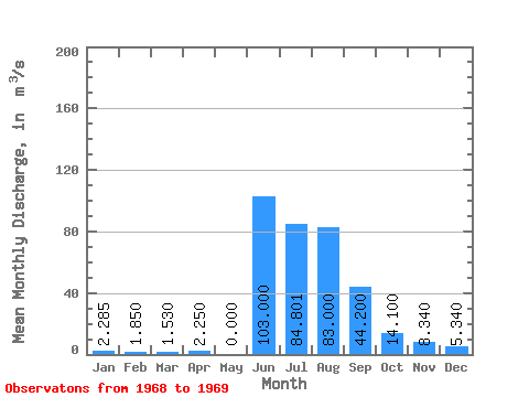
| Statistic | Jan | Feb | Mar | Apr | May | Jun | Jul | Aug | Sep | Oct | Nov | Dec | Annual |
|---|---|---|---|---|---|---|---|---|---|---|---|---|---|
| Mean | 2.29 | 1.85 | 1.53 | 2.25 | 0.00 | 103.00 | 84.80 | 83.00 | 44.20 | 14.10 | 8.34 | 5.34 | 28.57 |
| Standard Deviation | 3.23 | 2.62 | 2.16 | 3.18 | |||||||||
| Min | 0.00 | 0.00 | 0.00 | 0.00 | 0.00 | 103.00 | 84.80 | 83.00 | 44.20 | 14.10 | 8.34 | 5.34 | 28.57 |
| Max | 4.57 | 3.70 | 3.06 | 4.50 | 0.00 | 103.00 | 84.80 | 83.00 | 44.20 | 14.10 | 8.34 | 5.34 | 28.57 |
| Coefficient of Variation | 1.41 | 1.41 | 1.41 | 1.41 |
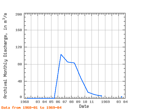
| Year | Jan | Feb | Mar | Apr | May | Jun | Jul | Aug | Sep | Oct | Nov | Dec | Annual | 1968 | 0.00 | 0.00 | 0.00 | 0.00 | 0.00 | 103.00 | 84.80 | 83.00 | 44.20 | 14.10 | 8.34 | 5.34 | 28.57 | 1969 | 4.57 | 3.70 | 3.06 | 4.50 |
|---|
 Return to R-Arctic Net Home Page