|
|
|||||||||||||||||
| Point ID: 7989 | Downloads | Plots | Site Data | Code: 3639 |
|
|
|||||||||||||||||
| Download | |
|---|---|
| Site Descriptor Information | Site Time Series Data |
| Link to all available data | |
|
|
| View: | Statistics | Time Series |
| Units: | mm |
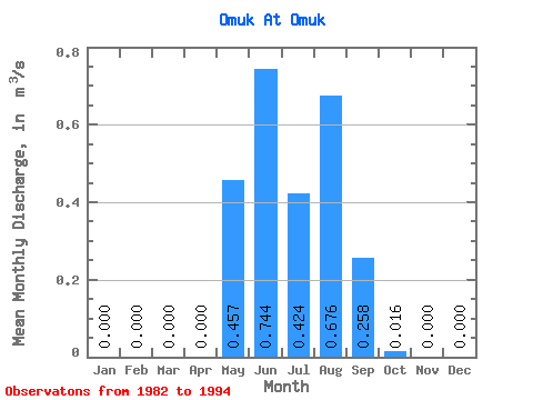
| Statistic | Jan | Feb | Mar | Apr | May | Jun | Jul | Aug | Sep | Oct | Nov | Dec | Annual |
|---|---|---|---|---|---|---|---|---|---|---|---|---|---|
| Mean | 0.00 | 0.00 | 0.00 | 0.00 | 0.46 | 0.74 | 0.42 | 0.68 | 0.26 | 0.02 | 0.00 | 0.00 | 0.12 |
| Standard Deviation | 0.00 | 0.00 | 0.00 | 0.00 | 0.47 | 0.70 | 0.34 | 0.67 | 0.36 | 0.04 | 0.00 | 0.00 | |
| Min | 0.00 | 0.00 | 0.00 | 0.00 | 0.03 | 0.01 | 0.03 | 0.13 | -0.22 | 0.00 | 0.00 | 0.00 | 0.12 |
| Max | 0.00 | 0.00 | 0.00 | 0.00 | 1.52 | 2.22 | 1.02 | 2.13 | 1.08 | 0.10 | 0.00 | 0.00 | 0.12 |
| Coefficient of Variation | 1.04 | 0.94 | 0.81 | 0.98 | 1.41 | 2.17 |
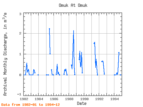
| Year | Jan | Feb | Mar | Apr | May | Jun | Jul | Aug | Sep | Oct | Nov | Dec | Annual | 1982 | 0.00 | 0.00 | 0.00 | 0.00 | 0.34 | 0.57 | 0.13 | 0.19 | 0.27 | 0.00 | 0.00 | 0.00 | 0.12 | 1983 | 0.00 | 0.00 | 0.00 | 0.00 | 0.25 | 0.22 | 0.10 | 0.00 | 1985 | 0.00 | 0.00 | 0.00 | 0.00 | 2.22 | 1.02 | 0.24 | 0.00 | 0.00 | 0.00 | 1986 | 0.03 | 0.51 | 0.03 | 0.13 | 0.03 | 0.00 | 1987 | 0.03 | 0.25 | 0.18 | 0.28 | 0.12 | 0.00 | 1988 | 0.47 | 0.28 | 0.92 | 2.13 | 0.43 | 0.01 | 1989 | 0.74 | 1.14 | 0.38 | 0.47 | 1.08 | 0.10 | 1991 | 1.52 | 1.57 | 0.36 | 0.76 | 0.34 | 0.00 | 1992 | 0.64 | 0.67 | 0.66 | 0.38 | 0.04 | 1994 | 0.00 | 0.00 | 0.00 | 0.00 | 0.10 | 0.01 | 0.46 | 1.07 | -0.22 | 0.00 | 0.00 |
|---|
 Return to R-Arctic Net Home Page