|
|
|||||||||||||||||
| Point ID: 7983 | Downloads | Plots | Site Data | Code: 3628 |
|
|
|||||||||||||||||
| Download | |
|---|---|
| Site Descriptor Information | Site Time Series Data |
| Link to all available data | |
|

|
| View: | Statistics | Time Series |
| Units: | mm |
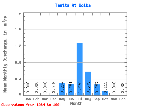
| Statistic | Jan | Feb | Mar | Apr | May | Jun | Jul | Aug | Sep | Oct | Nov | Dec | Annual |
|---|---|---|---|---|---|---|---|---|---|---|---|---|---|
| Mean | 0.00 | 0.00 | 0.00 | 0.01 | 0.29 | 0.28 | 1.27 | 0.57 | 0.27 | 0.12 | 0.00 | 0.00 | 0.45 |
| Standard Deviation | 0.00 | 0.00 | 0.00 | 0.02 | 0.31 | 0.32 | 2.75 | 0.75 | 0.33 | 0.19 | 0.00 | 0.00 | 0.52 |
| Min | 0.00 | 0.00 | 0.00 | 0.00 | 0.01 | 0.00 | 0.01 | 0.00 | 0.00 | 0.00 | 0.00 | 0.00 | 0.08 |
| Max | 0.00 | 0.00 | 0.00 | 0.04 | 0.76 | 0.86 | 6.19 | 1.51 | 0.65 | 0.40 | 0.00 | 0.00 | 0.81 |
| Coefficient of Variation | 1.56 | 1.05 | 1.15 | 2.17 | 1.31 | 1.23 | 1.66 | 1.17 |
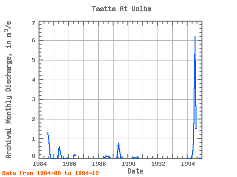
| Year | Jan | Feb | Mar | Apr | May | Jun | Jul | Aug | Sep | Oct | Nov | Dec | Annual | 1984 | 1.28 | 0.65 | 0.02 | 0.00 | 0.00 | 1985 | 0.00 | 0.00 | 0.00 | 0.04 | 0.59 | 0.29 | 0.02 | 0.00 | 0.00 | 0.00 | 0.00 | 0.00 | 0.08 | 1986 | 0.14 | 0.14 | 1988 | 0.05 | 0.00 | 0.12 | 0.08 | 0.09 | 0.04 | 1989 | 0.00 | 0.76 | 0.39 | 0.01 | 1990 | 0.01 | 0.00 | 0.01 | 0.00 | 0.00 | 1994 | 0.00 | 0.00 | 0.00 | 0.00 | 0.21 | 0.86 | 6.19 | 1.51 | 0.60 | 0.40 | 0.00 | 0.00 | 0.81 |
|---|
 Return to R-Arctic Net Home Page