|
|
|||||||||||||||||
| Point ID: 7978 | Downloads | Plots | Site Data | Code: 3620 |
|
|
|||||||||||||||||
| Download | |
|---|---|
| Site Descriptor Information | Site Time Series Data |
| Link to all available data | |
|
|
| View: | Statistics | Time Series |
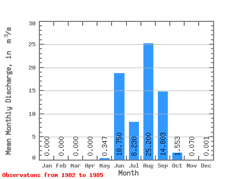
| Units: | mm |
| Statistic | Jan | Feb | Mar | Apr | May | Jun | Jul | Aug | Sep | Oct | Nov | Dec | Annual |
|---|---|---|---|---|---|---|---|---|---|---|---|---|---|
| Mean | 0.00 | 0.00 | 0.00 | 0.00 | 0.35 | 18.75 | 8.23 | 25.20 | 14.80 | 1.55 | 0.07 | 0.00 | 5.75 |
| Standard Deviation | 0.00 | 0.00 | 0.00 | 0.00 | 0.69 | 5.36 | 9.88 | 9.32 | 11.59 | 1.18 | 0.09 | 0.00 | 1.98 |
| Min | 0.00 | 0.00 | 0.00 | 0.00 | 0.00 | 12.00 | 1.42 | 14.50 | 5.19 | 0.49 | 0.00 | 0.00 | 3.78 |
| Max | 0.00 | 0.00 | 0.00 | 0.00 | 1.39 | 23.40 | 22.90 | 33.40 | 31.50 | 2.90 | 0.20 | 0.00 | 7.65 |
| Coefficient of Variation | 2.00 | 0.29 | 1.20 | 0.37 | 0.78 | 0.76 | 1.28 | 2.00 | 0.34 |
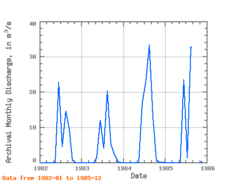
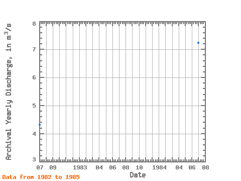
| Year | Jan | Feb | Mar | Apr | May | Jun | Jul | Aug | Sep | Oct | Nov | Dec | Annual | 1982 | 0.00 | 0.00 | 0.00 | 0.00 | 0.00 | 22.70 | 4.54 | 14.50 | 9.42 | 0.63 | 0.00 | 0.00 | 4.32 | 1983 | 0.00 | 0.00 | 0.00 | 0.00 | 1.39 | 12.00 | 4.06 | 20.30 | 5.19 | 2.19 | 0.20 | 0.00 | 3.78 | 1984 | 0.00 | 0.00 | 0.00 | 0.00 | 0.00 | 16.90 | 22.90 | 33.40 | 13.10 | 0.49 | 0.06 | 0.00 | 7.24 | 1985 | 0.00 | 0.00 | 0.00 | 0.00 | 0.00 | 23.40 | 1.42 | 32.60 | 31.50 | 2.90 | 0.03 | 0.00 | 7.65 |
|---|
 Return to R-Arctic Net Home Page