|
|
|||||||||||||||||
| Point ID: 7967 | Downloads | Plots | Site Data | Code: 3608 |
|
|
|||||||||||||||||
| Download | |
|---|---|
| Site Descriptor Information | Site Time Series Data |
| Link to all available data | |
|
|
| View: | Statistics | Time Series |
| Units: | mm |
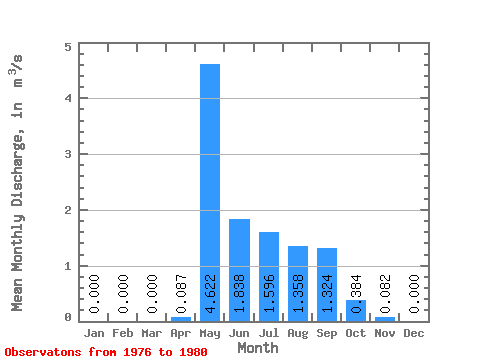
| Statistic | Jan | Feb | Mar | Apr | May | Jun | Jul | Aug | Sep | Oct | Nov | Dec | Annual |
|---|---|---|---|---|---|---|---|---|---|---|---|---|---|
| Mean | 0.00 | 0.00 | 0.00 | 0.09 | 4.62 | 1.84 | 1.60 | 1.36 | 1.32 | 0.38 | 0.08 | 0.00 | 0.94 |
| Standard Deviation | 0.00 | 0.00 | 0.00 | 0.12 | 0.69 | 0.60 | 0.55 | 0.95 | 0.58 | 0.25 | 0.08 | 0.00 | 0.11 |
| Min | 0.00 | 0.00 | 0.00 | 0.00 | 3.65 | 1.09 | 0.97 | 0.35 | 0.63 | 0.16 | 0.01 | 0.00 | 0.76 |
| Max | 0.00 | 0.00 | 0.00 | 0.27 | 5.36 | 2.40 | 2.22 | 2.93 | 2.15 | 0.72 | 0.20 | 0.00 | 1.06 |
| Coefficient of Variation | 1.35 | 0.15 | 0.33 | 0.35 | 0.70 | 0.44 | 0.65 | 0.98 | 2.24 | 0.12 |
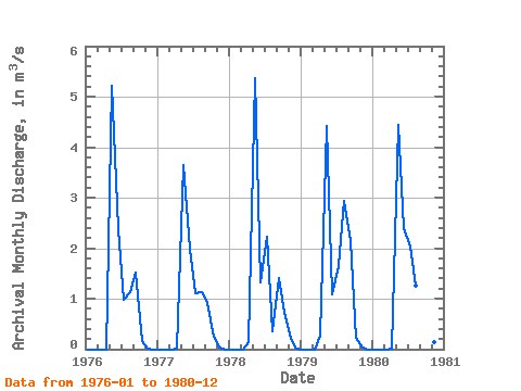
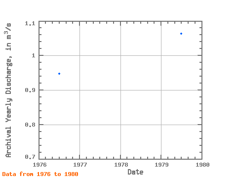
| Year | Jan | Feb | Mar | Apr | May | Jun | Jul | Aug | Sep | Oct | Nov | Dec | Annual | 1976 | 0.00 | 0.00 | 0.00 | 0.00 | 5.22 | 2.37 | 0.97 | 1.13 | 1.51 | 0.16 | 0.01 | 0.00 | 0.95 | 1977 | 0.00 | 0.00 | 0.00 | 0.00 | 3.65 | 2.00 | 1.10 | 1.13 | 0.92 | 0.24 | 0.04 | 0.00 | 0.76 | 1978 | 0.00 | 0.00 | 0.00 | 0.14 | 5.36 | 1.33 | 2.22 | 0.35 | 1.41 | 0.72 | 0.20 | 0.00 | 0.98 | 1979 | 0.00 | 0.00 | 0.00 | 0.27 | 4.43 | 1.09 | 1.65 | 2.93 | 2.15 | 0.22 | 0.02 | 0.00 | 1.06 | 1980 | 0.00 | 0.00 | 0.00 | 0.02 | 4.45 | 2.40 | 2.04 | 1.25 | 0.63 | 0.58 | 0.13 | 0.00 | 0.96 |
|---|
 Return to R-Arctic Net Home Page