|
|
|||||||||||||||||
| Point ID: 7963 | Downloads | Plots | Site Data | Code: 3602 |
|
|
|||||||||||||||||
| Download | |
|---|---|
| Site Descriptor Information | Site Time Series Data |
| Link to all available data | |
|
|
| View: | Statistics | Time Series |
| Units: | mm |
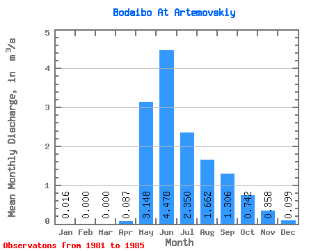
| Statistic | Jan | Feb | Mar | Apr | May | Jun | Jul | Aug | Sep | Oct | Nov | Dec | Annual |
|---|---|---|---|---|---|---|---|---|---|---|---|---|---|
| Mean | 0.02 | 0.00 | 0.00 | 0.09 | 3.15 | 4.48 | 2.35 | 1.66 | 1.31 | 0.74 | 0.36 | 0.10 | 1.19 |
| Standard Deviation | 0.03 | 0.00 | 0.00 | 0.12 | 0.86 | 1.68 | 1.27 | 1.09 | 0.62 | 0.26 | 0.21 | 0.09 | 0.35 |
| Min | 0.00 | 0.00 | 0.00 | 0.00 | 2.39 | 2.94 | 0.79 | 0.43 | 0.72 | 0.37 | 0.13 | 0.00 | 0.76 |
| Max | 0.07 | 0.00 | 0.00 | 0.29 | 4.55 | 6.82 | 4.09 | 2.90 | 2.08 | 1.08 | 0.55 | 0.20 | 1.59 |
| Coefficient of Variation | 1.78 | 1.35 | 0.27 | 0.38 | 0.54 | 0.66 | 0.48 | 0.35 | 0.58 | 0.92 | 0.30 |
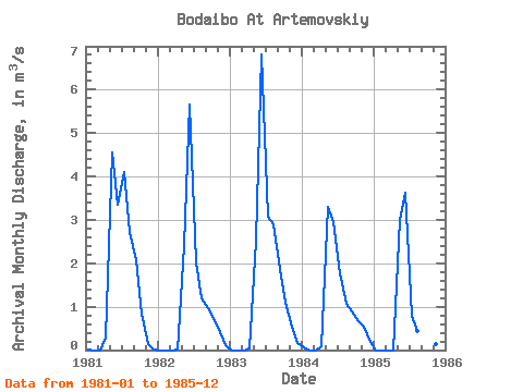
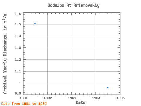
| Year | Jan | Feb | Mar | Apr | May | Jun | Jul | Aug | Sep | Oct | Nov | Dec | Annual | 1981 | 0.01 | 0.00 | 0.00 | 0.29 | 4.55 | 3.34 | 4.09 | 2.72 | 2.08 | 0.85 | 0.13 | 0.00 | 1.50 | 1982 | 0.00 | 0.00 | 0.00 | 0.02 | 2.39 | 5.66 | 2.03 | 1.20 | 0.96 | 0.74 | 0.41 | 0.11 | 1.13 | 1983 | 0.00 | 0.00 | 0.00 | 0.05 | 2.52 | 6.82 | 3.08 | 2.90 | 1.88 | 1.08 | 0.55 | 0.17 | 1.59 | 1984 | 0.07 | 0.00 | 0.00 | 0.08 | 3.29 | 2.94 | 1.76 | 1.06 | 0.89 | 0.67 | 0.55 | 0.20 | 0.96 | 1985 | 0.00 | 0.00 | 0.00 | 0.00 | 2.99 | 3.63 | 0.79 | 0.43 | 0.72 | 0.37 | 0.15 | 0.01 | 0.76 |
|---|
 Return to R-Arctic Net Home Page