|
|
|||||||||||||||||
| Point ID: 7962 | Downloads | Plots | Site Data | Code: 3601 |
|
|
|||||||||||||||||
| Download | |
|---|---|
| Site Descriptor Information | Site Time Series Data |
| Link to all available data | |
| View: | Time Series | All |
| Units: | m3/s |
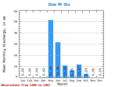
| Statistic | Jan | Feb | Mar | Apr | May | Jun | Jul | Aug | Sep | Oct | Nov | Dec | Annual |
|---|---|---|---|---|---|---|---|---|---|---|---|---|---|
| Mean | 0.00 | 0.00 | 0.00 | 0.43 | 51.34 | 31.45 | 10.85 | 6.65 | 11.67 | 3.24 | 0.06 | 0.00 | 133.76 |
| Standard Deviation | 0.00 | 0.00 | 0.00 | 0.58 | 27.69 | 25.02 | 15.10 | 8.74 | 15.40 | 4.43 | 0.13 | 0.00 | 59.01 |
| Min | 0.00 | 0.00 | 0.00 | 0.00 | 8.62 | 1.95 | 0.01 | 0.00 | 0.00 | 0.00 | 0.00 | 0.00 | 39.06 |
| Max | 0.00 | 0.00 | 0.00 | 1.39 | 84.60 | 73.38 | 46.21 | 19.30 | 38.11 | 11.03 | 0.31 | 0.00 | 199.68 |
| Coefficient of Variation | 1.36 | 0.54 | 0.80 | 1.39 | 1.31 | 1.32 | 1.37 | 2.28 | 0.44 |
 Return to R-Arctic Net Home Page