|
|
|||||||||||||||||
| Point ID: 7962 | Downloads | Plots | Site Data | Code: 3601 |
|
|
|||||||||||||||||
| Download | |
|---|---|
| Site Descriptor Information | Site Time Series Data |
| Link to all available data | |
|
|
| View: | Statistics | Time Series |
| Units: | mm |
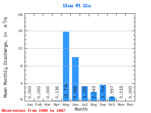
| Statistic | Jan | Feb | Mar | Apr | May | Jun | Jul | Aug | Sep | Oct | Nov | Dec | Annual |
|---|---|---|---|---|---|---|---|---|---|---|---|---|---|
| Mean | 0.00 | 0.00 | 0.00 | 0.14 | 15.78 | 9.99 | 3.33 | 2.04 | 3.70 | 1.00 | 0.02 | 0.00 | 3.49 |
| Standard Deviation | 0.00 | 0.00 | 0.00 | 0.18 | 8.51 | 7.95 | 4.64 | 2.69 | 4.89 | 1.36 | 0.04 | 0.00 | 1.54 |
| Min | 0.00 | 0.00 | 0.00 | 0.00 | 2.65 | 0.62 | 0.00 | 0.00 | 0.00 | 0.00 | 0.00 | 0.00 | 1.02 |
| Max | 0.00 | 0.00 | 0.00 | 0.44 | 26.00 | 23.30 | 14.20 | 5.93 | 12.10 | 3.39 | 0.10 | 0.00 | 5.21 |
| Coefficient of Variation | 1.36 | 0.54 | 0.80 | 1.39 | 1.31 | 1.32 | 1.37 | 2.28 | 0.44 |
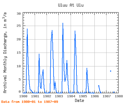
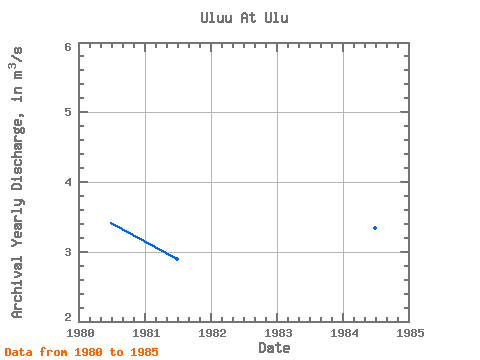
| Year | Jan | Feb | Mar | Apr | May | Jun | Jul | Aug | Sep | Oct | Nov | Dec | Annual | 1980 | 0.00 | 0.00 | 0.00 | 0.00 | 23.80 | 11.30 | 3.56 | 1.04 | 1.02 | 0.27 | 0.00 | 0.00 | 3.42 | 1981 | 0.00 | 0.00 | 0.00 | 0.00 | 14.50 | 2.24 | 1.61 | 5.93 | 8.65 | 1.86 | 0.00 | 0.00 | 2.90 | 1982 | 0.00 | 0.00 | 0.00 | 0.44 | 18.80 | 23.30 | 14.20 | 1.12 | 4.16 | 0.46 | 0.00 | 0.00 | 5.21 | 1983 | 0.00 | 0.00 | 0.00 | 0.00 | 26.00 | 8.71 | 4.30 | 5.91 | 12.10 | 3.39 | 0.10 | 0.00 | 5.04 | 1984 | 0.00 | 0.00 | 0.00 | 0.28 | 23.10 | 15.70 | 1.07 | 0.00 | 0.00 | 0.00 | 0.00 | 0.00 | 3.35 | 1985 | 0.00 | 0.00 | 0.00 | 0.09 | 9.20 | 2.73 | 0.20 | 0.00 | 0.00 | 0.00 | 0.00 | 0.00 | 1.02 | 1986 | 2.65 | 0.62 | 0.00 | 1987 | 8.16 | 15.30 | 1.72 | 0.30 | 0.00 |
|---|
 Return to R-Arctic Net Home Page