|
|
|||||||||||||||||
| Point ID: 7960 | Downloads | Plots | Site Data | Code: 3599 |
|
|
|||||||||||||||||
| Download | |
|---|---|
| Site Descriptor Information | Site Time Series Data |
| Link to all available data | |
| View: | Time Series | All |
| Units: | m3/s |
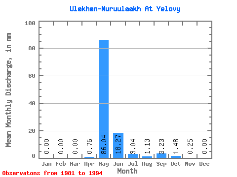
| Statistic | Jan | Feb | Mar | Apr | May | Jun | Jul | Aug | Sep | Oct | Nov | Dec | Annual |
|---|---|---|---|---|---|---|---|---|---|---|---|---|---|
| Mean | 0.00 | 0.00 | 0.00 | 0.75 | 86.01 | 18.26 | 3.06 | 1.14 | 3.22 | 1.46 | 0.26 | 0.00 | 117.94 |
| Standard Deviation | 0.00 | 0.00 | 0.00 | 1.53 | 27.95 | 12.09 | 4.28 | 1.43 | 4.48 | 3.04 | 0.54 | 0.00 | 41.87 |
| Min | 0.00 | 0.00 | 0.00 | 0.00 | 48.61 | 2.14 | 0.00 | 0.00 | 0.00 | 0.00 | 0.00 | 0.00 | 66.62 |
| Max | 0.00 | 0.00 | 0.00 | 4.20 | 131.95 | 45.79 | 12.15 | 4.34 | 11.34 | 10.42 | 1.55 | 0.00 | 169.14 |
| Coefficient of Variation | 2.04 | 0.33 | 0.66 | 1.40 | 1.26 | 1.39 | 2.09 | 2.04 | 0.35 |
 Return to R-Arctic Net Home Page