|
|
|||||||||||||||||
| Point ID: 7960 | Downloads | Plots | Site Data | Code: 3599 |
|
|
|||||||||||||||||
| Download | |
|---|---|
| Site Descriptor Information | Site Time Series Data |
| Link to all available data | |
|
|
| View: | Statistics | Time Series |
| Units: | mm |
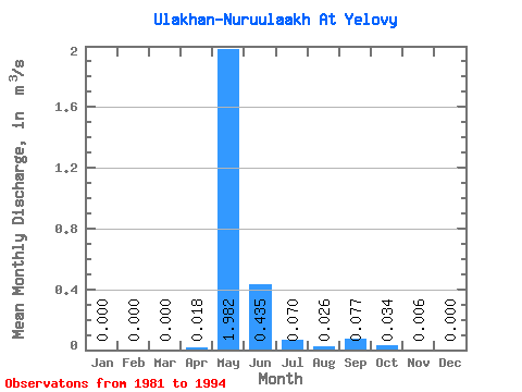
| Statistic | Jan | Feb | Mar | Apr | May | Jun | Jul | Aug | Sep | Oct | Nov | Dec | Annual |
|---|---|---|---|---|---|---|---|---|---|---|---|---|---|
| Mean | 0.00 | 0.00 | 0.00 | 0.02 | 1.98 | 0.43 | 0.07 | 0.03 | 0.08 | 0.03 | 0.01 | 0.00 | 0.23 |
| Standard Deviation | 0.00 | 0.00 | 0.00 | 0.04 | 0.64 | 0.29 | 0.10 | 0.03 | 0.11 | 0.07 | 0.01 | 0.00 | 0.08 |
| Min | 0.00 | 0.00 | 0.00 | 0.00 | 1.12 | 0.05 | 0.00 | 0.00 | 0.00 | 0.00 | 0.00 | 0.00 | 0.13 |
| Max | 0.00 | 0.00 | 0.00 | 0.10 | 3.04 | 1.09 | 0.28 | 0.10 | 0.27 | 0.24 | 0.04 | 0.00 | 0.33 |
| Coefficient of Variation | 2.04 | 0.33 | 0.66 | 1.40 | 1.26 | 1.39 | 2.09 | 2.04 | 0.35 |
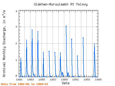
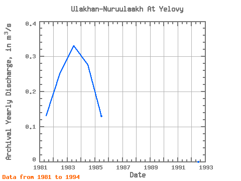
| Year | Jan | Feb | Mar | Apr | May | Jun | Jul | Aug | Sep | Oct | Nov | Dec | Annual | 1981 | 0.00 | 0.00 | 0.00 | 0.10 | 1.12 | 0.31 | 0.02 | 0.01 | 0.01 | 0.00 | 0.00 | 0.00 | 0.13 | 1982 | 0.00 | 0.00 | 0.00 | 0.01 | 2.22 | 0.40 | 0.24 | 0.07 | 0.10 | 0.03 | 0.00 | 0.00 | 0.26 | 1983 | 0.00 | 0.00 | 0.00 | 0.00 | 2.84 | 0.64 | 0.20 | 0.10 | 0.15 | 0.03 | 0.01 | 0.00 | 0.33 | 1984 | 0.00 | 0.00 | 0.00 | 0.00 | 2.75 | 0.54 | 0.02 | 0.00 | 0.00 | 0.00 | 0.00 | 0.00 | 0.28 | 1985 | 0.00 | 0.00 | 0.00 | 0.01 | 1.50 | 0.05 | 0.00 | 0.00 | 0.00 | 0.00 | 0.00 | 0.00 | 0.13 | 1986 | 1.52 | 0.27 | 0.00 | 0.01 | 0.03 | 0.00 | 1987 | 1.46 | 0.52 | 0.03 | 0.06 | 0.00 | 1988 | 0.01 | 1.46 | 0.36 | 0.28 | 0.03 | 0.27 | 0.24 | 0.04 | 1989 | 3.04 | 0.82 | 0.04 | 0.04 | 0.27 | 0.09 | 0.01 | 1990 | 2.26 | 0.13 | 0.02 | 0.01 | 0.01 | 0.01 | 1991 | 1.25 | 0.21 | 0.02 | 0.01 | 0.01 | 0.00 | 1992 | 2.34 | 0.31 | 0.02 | 0.00 | 1994 | 0.00 | 0.00 | 0.00 | 0.00 | 2.00 | 1.09 | 0.03 | 0.00 | 0.00 | 0.00 | 0.00 | 0.00 | 0.26 |
|---|
 Return to R-Arctic Net Home Page