|
|
|||||||||||||||||
| Point ID: 7959 | Downloads | Plots | Site Data | Code: 3598 |
|
|
|||||||||||||||||
| Download | |
|---|---|
| Site Descriptor Information | Site Time Series Data |
| Link to all available data | |
|
|
| View: | Statistics | Time Series |
| Units: | mm |
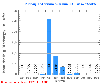
| Statistic | Jan | Feb | Mar | Apr | May | Jun | Jul | Aug | Sep | Oct | Nov | Dec | Annual |
|---|---|---|---|---|---|---|---|---|---|---|---|---|---|
| Mean | 0.00 | 0.00 | 0.00 | 0.01 | 0.51 | 0.18 | 0.07 | 0.01 | 0.02 | 0.00 | 0.00 | 0.00 | 0.08 |
| Standard Deviation | 0.00 | 0.00 | 0.00 | 0.02 | 0.37 | 0.13 | 0.14 | 0.02 | 0.05 | 0.01 | 0.00 | 0.00 | 0.04 |
| Min | 0.00 | 0.00 | 0.00 | 0.00 | 0.04 | 0.01 | 0.00 | 0.00 | 0.00 | 0.00 | 0.00 | 0.00 | 0.03 |
| Max | 0.00 | 0.00 | 0.00 | 0.05 | 1.12 | 0.33 | 0.37 | 0.06 | 0.14 | 0.02 | 0.00 | 0.00 | 0.15 |
| Coefficient of Variation | 2.54 | 0.73 | 0.76 | 2.02 | 2.12 | 2.23 | 2.37 | 0.49 |
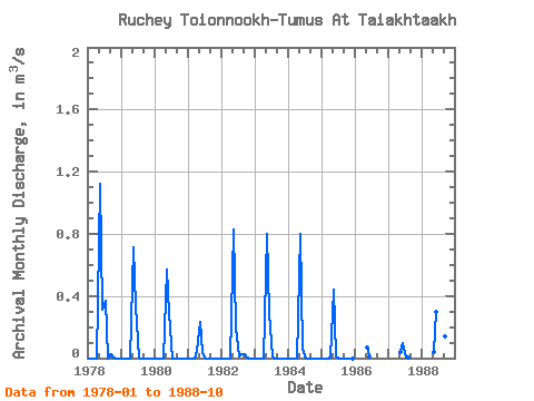
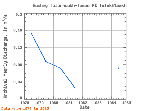
| Year | Jan | Feb | Mar | Apr | May | Jun | Jul | Aug | Sep | Oct | Nov | Dec | Annual | 1978 | 0.00 | 0.00 | 0.00 | 0.00 | 1.12 | 0.31 | 0.37 | 0.00 | 0.02 | 0.00 | 0.00 | 0.00 | 0.15 | 1979 | 0.00 | 0.00 | 0.00 | 0.00 | 0.71 | 0.33 | 0.01 | 0.00 | 0.00 | 0.00 | 0.00 | 0.00 | 0.09 | 1980 | 0.00 | 0.00 | 0.00 | 0.00 | 0.57 | 0.29 | 0.00 | 0.00 | 0.00 | 0.00 | 0.00 | 0.00 | 0.07 | 1981 | 0.00 | 0.00 | 0.00 | 0.05 | 0.23 | 0.03 | 0.00 | 0.00 | 0.00 | 0.00 | 0.00 | 0.00 | 0.03 | 1982 | 0.00 | 0.00 | 0.00 | 0.00 | 0.83 | 0.20 | 0.01 | 0.02 | 0.02 | 0.00 | 0.00 | 0.00 | 0.09 | 1983 | 0.00 | 0.00 | 0.00 | 0.00 | 0.80 | 0.29 | 0.01 | 0.00 | 0.00 | 0.00 | 0.00 | 0.00 | 0.09 | 1984 | 0.00 | 0.00 | 0.00 | 0.00 | 0.80 | 0.06 | 0.00 | 0.00 | 0.00 | 0.00 | 0.00 | 0.00 | 0.07 | 1985 | 0.00 | 0.00 | 0.00 | 0.01 | 0.44 | 0.01 | 0.00 | 0.00 | 0.00 | 0.00 | 0.00 | 0.00 | 0.04 | 1986 | 0.07 | 0.01 | 1987 | 0.04 | 0.10 | 0.00 | 0.01 | 1988 | 0.04 | 0.30 | 0.31 | 0.06 | 0.14 | 0.02 |
|---|
 Return to R-Arctic Net Home Page