|
|
|||||||||||||||||
| Point ID: 7945 | Downloads | Plots | Site Data | Code: 3575 |
|
|
|||||||||||||||||
| Download | |
|---|---|
| Site Descriptor Information | Site Time Series Data |
| Link to all available data | |
|
|
| View: | Statistics | Time Series |
| Units: | mm |
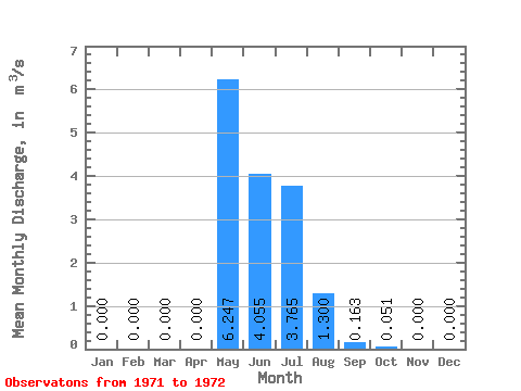
| Statistic | Jan | Feb | Mar | Apr | May | Jun | Jul | Aug | Sep | Oct | Nov | Dec | Annual |
|---|---|---|---|---|---|---|---|---|---|---|---|---|---|
| Mean | 0.00 | 0.00 | 0.00 | 0.00 | 6.25 | 4.05 | 3.77 | 1.30 | 0.16 | 0.05 | 0.00 | 0.00 | 1.30 |
| Standard Deviation | 0.00 | 0.00 | 0.00 | 0.00 | 8.70 | 2.13 | 3.53 | 0.48 | 0.10 | 0.02 | 0.00 | 0.00 | 0.22 |
| Min | 0.00 | 0.00 | 0.00 | 0.00 | 0.10 | 2.55 | 1.27 | 0.96 | 0.10 | 0.04 | 0.00 | 0.00 | 1.14 |
| Max | 0.00 | 0.00 | 0.00 | 0.00 | 12.40 | 5.56 | 6.26 | 1.64 | 0.23 | 0.07 | 0.00 | 0.00 | 1.46 |
| Coefficient of Variation | 1.39 | 0.53 | 0.94 | 0.37 | 0.58 | 0.37 | 0.17 |
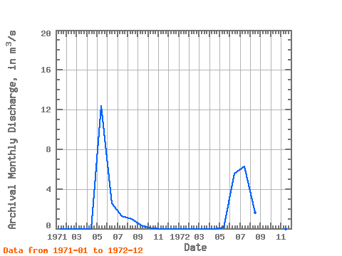
| Year | Jan | Feb | Mar | Apr | May | Jun | Jul | Aug | Sep | Oct | Nov | Dec | Annual | 1971 | 0.00 | 0.00 | 0.00 | 0.00 | 12.40 | 2.55 | 1.27 | 0.96 | 0.23 | 0.07 | 0.00 | 0.00 | 1.46 | 1972 | 0.00 | 0.00 | 0.00 | 0.00 | 0.10 | 5.56 | 6.26 | 1.64 | 0.10 | 0.04 | 0.00 | 0.00 | 1.14 |
|---|
 Return to R-Arctic Net Home Page