|
|
|||||||||||||||||
| Point ID: 7942 | Downloads | Plots | Site Data | Code: 3571 |
|
|
|||||||||||||||||
| Download | |
|---|---|
| Site Descriptor Information | Site Time Series Data |
| Link to all available data | |
|
|
| View: | Statistics | Time Series |
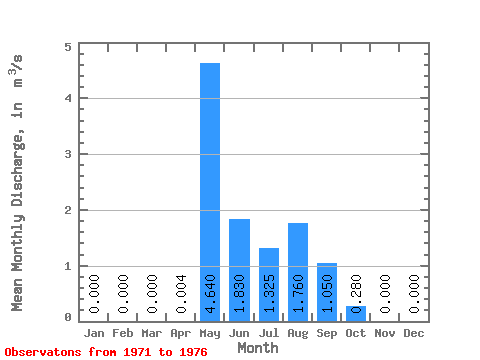
| Units: | mm |
| Statistic | Jan | Feb | Mar | Apr | May | Jun | Jul | Aug | Sep | Oct | Nov | Dec | Annual |
|---|---|---|---|---|---|---|---|---|---|---|---|---|---|
| Mean | 0.00 | 0.00 | 0.00 | 0.00 | 4.64 | 1.83 | 1.32 | 1.76 | 1.05 | 0.28 | 0.00 | 0.00 | 0.88 |
| Standard Deviation | 0.00 | 0.00 | 0.00 | 0.06 | 0.33 | 0.68 | 0.00 | ||||||
| Min | 0.00 | 0.00 | 0.00 | 0.00 | 4.64 | 1.79 | 1.09 | 1.28 | 1.05 | 0.28 | 0.00 | 0.00 | 0.88 |
| Max | 0.00 | 0.00 | 0.00 | 0.00 | 4.64 | 1.87 | 1.56 | 2.24 | 1.05 | 0.28 | 0.00 | 0.00 | 0.88 |
| Coefficient of Variation | 0.03 | 0.25 | 0.39 |
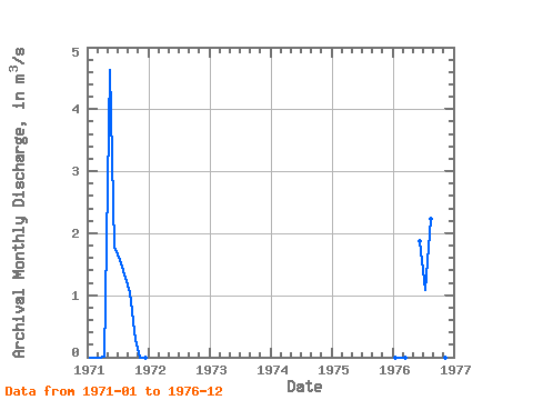
| Year | Jan | Feb | Mar | Apr | May | Jun | Jul | Aug | Sep | Oct | Nov | Dec | Annual | 1971 | 0.00 | 0.00 | 0.00 | 0.00 | 4.64 | 1.79 | 1.56 | 1.28 | 1.05 | 0.28 | 0.00 | 0.00 | 0.88 | 1976 | 0.00 | 0.00 | 0.00 | 1.87 | 1.09 | 2.24 | 0.00 |
|---|
 Return to R-Arctic Net Home Page