|
|
|||||||||||||||||
| Point ID: 7936 | Downloads | Plots | Site Data | Code: 3557 |
|
|
|||||||||||||||||
| Download | |
|---|---|
| Site Descriptor Information | Site Time Series Data |
| Link to all available data | |
|
|
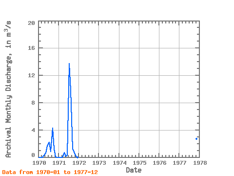
| View: | Statistics | Time Series |
| Units: | mm |
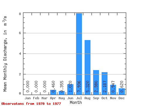
| Statistic | Jan | Feb | Mar | Apr | May | Jun | Jul | Aug | Sep | Oct | Nov | Dec | Annual |
|---|---|---|---|---|---|---|---|---|---|---|---|---|---|
| Mean | 0.00 | 0.00 | 0.00 | 0.46 | 0.35 | 1.02 | 7.94 | 5.32 | 2.38 | 2.19 | 0.95 | 0.62 | 1.57 |
| Standard Deviation | 0.00 | 0.00 | 0.00 | 0.34 | 0.32 | 0.99 | 8.15 | 6.35 | 1.67 | 2.11 | 1.53 | 1.07 | 0.92 |
| Min | 0.00 | 0.00 | 0.00 | 0.22 | 0.13 | 0.32 | 2.17 | 0.83 | 1.20 | 0.76 | 0.06 | 0.00 | 0.92 |
| Max | 0.00 | 0.00 | 0.00 | 0.70 | 0.58 | 1.72 | 13.70 | 9.81 | 4.29 | 4.61 | 2.71 | 1.86 | 2.23 |
| Coefficient of Variation | 0.74 | 0.90 | 0.97 | 1.03 | 1.19 | 0.70 | 0.96 | 1.61 | 1.73 | 0.59 |
| Year | Jan | Feb | Mar | Apr | May | Jun | Jul | Aug | Sep | Oct | Nov | Dec | Annual | 1970 | 0.00 | 0.00 | 0.00 | 0.22 | 0.58 | 1.72 | 2.17 | 0.83 | 4.29 | 1.19 | 0.06 | 0.00 | 0.92 | 1971 | 0.00 | 0.00 | 0.00 | 0.70 | 0.13 | 0.32 | 13.70 | 9.81 | 1.20 | 0.76 | 0.07 | 0.00 | 2.23 | 1977 | 1.65 | 4.61 | 2.71 | 1.86 |
|---|
 Return to R-Arctic Net Home Page