|
|
|||||||||||||||||
| Point ID: 7929 | Downloads | Plots | Site Data | Code: 3516 |
|
|
|||||||||||||||||
| Download | |
|---|---|
| Site Descriptor Information | Site Time Series Data |
| Link to all available data | |
| View: | Time Series | All |
| Units: | m3/s |
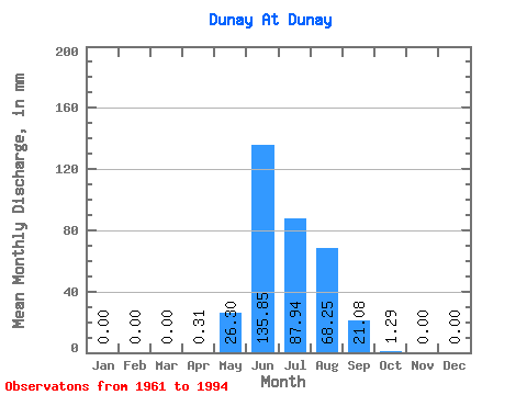
| Statistic | Jan | Feb | Mar | Apr | May | Jun | Jul | Aug | Sep | Oct | Nov | Dec | Annual |
|---|---|---|---|---|---|---|---|---|---|---|---|---|---|
| Mean | 0.00 | 0.00 | 0.00 | 0.37 | 26.34 | 135.90 | 87.85 | 68.25 | 21.03 | 1.30 | 0.00 | 0.00 | 339.91 |
| Standard Deviation | 0.00 | 0.00 | 0.00 | 0.60 | 22.59 | 54.00 | 32.45 | 37.07 | 17.76 | 2.72 | 0.00 | 0.00 | 87.22 |
| Min | 0.00 | 0.00 | 0.00 | 0.00 | 1.94 | 42.16 | 22.59 | 11.29 | 1.56 | 0.00 | 0.00 | 0.00 | 215.63 |
| Max | 0.00 | 0.00 | 0.00 | 1.72 | 90.34 | 262.32 | 148.42 | 140.35 | 67.14 | 15.00 | 0.00 | 0.00 | 547.07 |
| Coefficient of Variation | 1.62 | 0.86 | 0.40 | 0.37 | 0.54 | 0.84 | 2.08 | 0.26 |
 Return to R-Arctic Net Home Page