|
|
|||||||||||||||||
| Point ID: 7915 | Downloads | Plots | Site Data | Code: 3455 |
|
|
|||||||||||||||||
| Download | |
|---|---|
| Site Descriptor Information | Site Time Series Data |
| Link to all available data | |
|
|
| View: | Statistics | Time Series |
| Units: | mm |
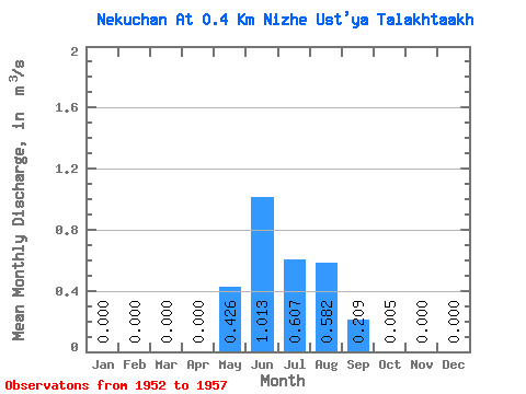
| Statistic | Jan | Feb | Mar | Apr | May | Jun | Jul | Aug | Sep | Oct | Nov | Dec | Annual |
|---|---|---|---|---|---|---|---|---|---|---|---|---|---|
| Mean | 0.00 | 0.00 | 0.00 | 0.00 | 0.43 | 1.01 | 0.61 | 0.58 | 0.21 | 0.01 | 0.00 | 0.00 | 0.23 |
| Standard Deviation | 0.00 | 0.00 | 0.00 | 0.00 | 0.49 | 0.51 | 0.24 | 0.23 | 0.20 | 0.00 | 0.00 | 0.00 | 0.05 |
| Min | 0.00 | 0.00 | 0.00 | 0.00 | 0.00 | 0.42 | 0.16 | 0.34 | 0.03 | 0.00 | 0.00 | 0.00 | 0.17 |
| Max | 0.00 | 0.00 | 0.00 | 0.00 | 1.14 | 1.86 | 0.80 | 0.87 | 0.55 | 0.01 | 0.00 | 0.00 | 0.32 |
| Coefficient of Variation | 1.14 | 0.51 | 0.40 | 0.40 | 0.97 | 0.43 | 0.24 |
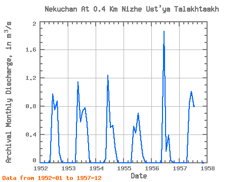
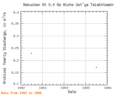
| Year | Jan | Feb | Mar | Apr | May | Jun | Jul | Aug | Sep | Oct | Nov | Dec | Annual | 1952 | 0.00 | 0.00 | 0.00 | 0.00 | 0.01 | 0.97 | 0.75 | 0.87 | 0.14 | 0.01 | 0.00 | 0.00 | 0.23 | 1953 | 0.00 | 0.00 | 0.00 | 0.00 | 1.14 | 0.58 | 0.73 | 0.78 | 0.55 | 0.00 | 0.00 | 0.00 | 0.32 | 1954 | 0.00 | 0.00 | 0.00 | 0.00 | 0.05 | 1.24 | 0.50 | 0.53 | 0.23 | 0.01 | 0.00 | 0.00 | 0.21 | 1955 | 0.00 | 0.00 | 0.00 | 0.00 | 0.51 | 0.42 | 0.70 | 0.34 | 0.09 | 0.00 | 0.00 | 0.00 | 0.17 | 1956 | 0.00 | 0.00 | 0.00 | 0.00 | 0.00 | 1.86 | 0.16 | 0.39 | 0.03 | 0.01 | 0.00 | 0.00 | 0.20 | 1957 | 0.00 | 0.00 | 0.00 | 0.00 | 0.84 | 1.01 | 0.80 | 0.00 | 0.00 |
|---|
 Return to R-Arctic Net Home Page