|
|
|||||||||||||||||
| Point ID: 7894 | Downloads | Plots | Site Data | Code: 3381 |
|
|
|||||||||||||||||
| Download | |
|---|---|
| Site Descriptor Information | Site Time Series Data |
| Link to all available data | |
|
|
| View: | Statistics | Time Series |
| Units: | mm |
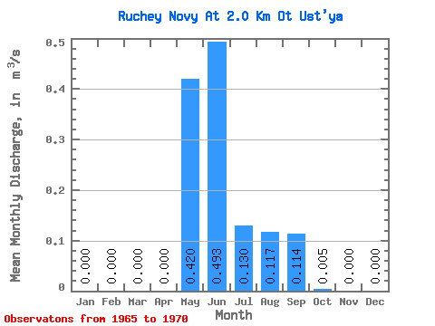
| Statistic | Jan | Feb | Mar | Apr | May | Jun | Jul | Aug | Sep | Oct | Nov | Dec | Annual |
|---|---|---|---|---|---|---|---|---|---|---|---|---|---|
| Mean | 0.00 | 0.00 | 0.00 | 0.00 | 0.42 | 0.49 | 0.13 | 0.12 | 0.11 | 0.01 | 0.00 | 0.00 | 0.11 |
| Standard Deviation | 0.00 | 0.00 | 0.00 | 0.00 | 0.23 | 0.26 | 0.10 | 0.12 | 0.06 | 0.01 | 0.00 | 0.00 | 0.03 |
| Min | 0.00 | 0.00 | 0.00 | 0.00 | 0.13 | 0.19 | 0.02 | 0.01 | 0.04 | 0.00 | 0.00 | 0.00 | 0.06 |
| Max | 0.00 | 0.00 | 0.00 | 0.00 | 0.77 | 0.86 | 0.31 | 0.34 | 0.18 | 0.02 | 0.00 | 0.00 | 0.15 |
| Coefficient of Variation | 0.54 | 0.53 | 0.79 | 0.99 | 0.51 | 1.50 | 0.28 |
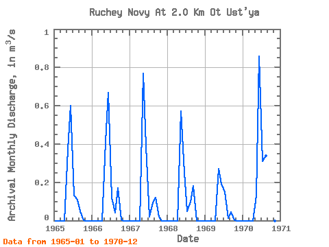
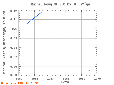
| Year | Jan | Feb | Mar | Apr | May | Jun | Jul | Aug | Sep | Oct | Nov | Dec | Annual | 1965 | 0.00 | 0.00 | 0.00 | 0.00 | 0.37 | 0.60 | 0.13 | 0.11 | 0.05 | 0.00 | 0.00 | 0.00 | 0.10 | 1966 | 0.00 | 0.00 | 0.00 | 0.00 | 0.41 | 0.67 | 0.12 | 0.04 | 0.17 | 0.01 | 0.00 | 0.00 | 0.12 | 1967 | 0.00 | 0.00 | 0.00 | 0.00 | 0.77 | 0.39 | 0.02 | 0.10 | 0.12 | 0.02 | 0.00 | 0.00 | 0.12 | 1968 | 0.00 | 0.00 | 0.00 | 0.00 | 0.57 | 0.25 | 0.05 | 0.10 | 0.18 | 0.00 | 0.00 | 0.00 | 0.10 | 1969 | 0.00 | 0.00 | 0.00 | 0.00 | 0.27 | 0.19 | 0.15 | 0.01 | 0.04 | 0.00 | 0.00 | 0.00 | 0.06 | 1970 | 0.00 | 0.00 | 0.00 | 0.00 | 0.13 | 0.86 | 0.31 | 0.34 | 0.12 | 0.00 | 0.00 | 0.00 | 0.15 |
|---|
 Return to R-Arctic Net Home Page