|
|
|||||||||||||||||
| Point ID: 7891 | Downloads | Plots | Site Data | Code: 3376 |
|
|
|||||||||||||||||
| Download | |
|---|---|
| Site Descriptor Information | Site Time Series Data |
| Link to all available data | |
|
|
| View: | Statistics | Time Series |
| Units: | mm |
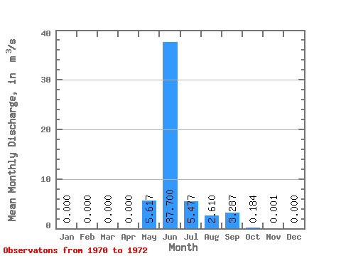
| Statistic | Jan | Feb | Mar | Apr | May | Jun | Jul | Aug | Sep | Oct | Nov | Dec | Annual |
|---|---|---|---|---|---|---|---|---|---|---|---|---|---|
| Mean | 0.00 | 0.00 | 0.00 | 0.00 | 5.62 | 37.70 | 5.48 | 2.61 | 3.29 | 0.18 | 0.00 | 0.00 | 4.57 |
| Standard Deviation | 0.00 | 0.00 | 0.00 | 0.00 | 5.47 | 16.96 | 4.51 | 4.15 | 3.25 | 0.12 | 0.00 | 0.00 | 1.72 |
| Min | 0.00 | 0.00 | 0.00 | 0.00 | 1.89 | 18.30 | 0.28 | 0.01 | 1.13 | 0.04 | 0.00 | 0.00 | 2.64 |
| Max | 0.00 | 0.00 | 0.00 | 0.00 | 11.90 | 49.70 | 8.39 | 7.40 | 7.03 | 0.26 | 0.00 | 0.00 | 5.94 |
| Coefficient of Variation | 0.97 | 0.45 | 0.82 | 1.59 | 0.99 | 0.67 | 1.73 | 0.38 |
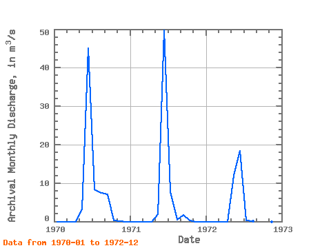
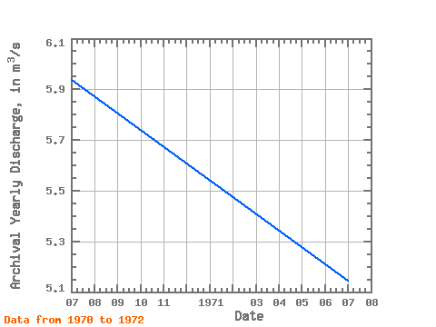
| Year | Jan | Feb | Mar | Apr | May | Jun | Jul | Aug | Sep | Oct | Nov | Dec | Annual | 1970 | 0.00 | 0.00 | 0.00 | 0.00 | 3.06 | 45.10 | 8.39 | 7.40 | 7.03 | 0.25 | 0.00 | 0.00 | 5.94 | 1971 | 0.00 | 0.00 | 0.00 | 0.00 | 1.89 | 49.70 | 7.76 | 0.42 | 1.70 | 0.26 | 0.00 | 0.00 | 5.14 | 1972 | 0.00 | 0.00 | 0.00 | 0.00 | 11.90 | 18.30 | 0.28 | 0.01 | 1.13 | 0.04 | 0.00 | 0.00 | 2.64 |
|---|
 Return to R-Arctic Net Home Page