|
|
|||||||||||||||||
| Point ID: 7887 | Downloads | Plots | Site Data | Code: 3371 |
|
|
|||||||||||||||||
| Download | |
|---|---|
| Site Descriptor Information | Site Time Series Data |
| Link to all available data | |
|
|
| View: | Statistics | Time Series |
| Units: | mm |
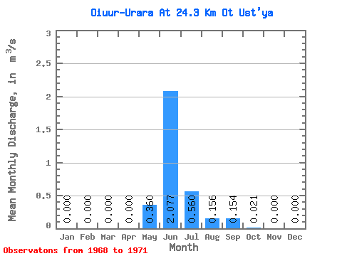
| Statistic | Jan | Feb | Mar | Apr | May | Jun | Jul | Aug | Sep | Oct | Nov | Dec | Annual |
|---|---|---|---|---|---|---|---|---|---|---|---|---|---|
| Mean | 0.00 | 0.00 | 0.00 | 0.00 | 0.36 | 2.08 | 0.56 | 0.16 | 0.15 | 0.02 | 0.00 | 0.00 | 0.28 |
| Standard Deviation | 0.00 | 0.00 | 0.00 | 0.00 | 0.42 | 1.06 | 0.18 | 0.17 | 0.15 | 0.02 | 0.00 | 0.00 | 0.06 |
| Min | 0.00 | 0.00 | 0.00 | 0.00 | 0.00 | 0.84 | 0.37 | 0.01 | 0.01 | 0.00 | 0.00 | 0.00 | 0.19 |
| Max | 0.00 | 0.00 | 0.00 | 0.00 | 0.78 | 3.12 | 0.80 | 0.36 | 0.30 | 0.06 | 0.00 | 0.00 | 0.33 |
| Coefficient of Variation | 1.16 | 0.51 | 0.33 | 1.11 | 0.99 | 1.09 | 2.00 | 0.22 |
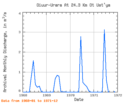
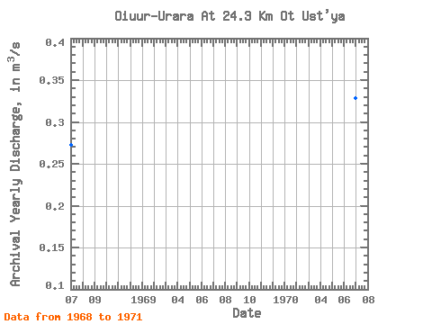
| Year | Jan | Feb | Mar | Apr | May | Jun | Jul | Aug | Sep | Oct | Nov | Dec | Annual | 1968 | 0.00 | 0.00 | 0.00 | 0.00 | 0.78 | 1.57 | 0.37 | 0.24 | 0.30 | 0.01 | 0.00 | 0.00 | 0.27 | 1969 | 0.00 | 0.00 | 0.00 | 0.00 | 0.66 | 0.84 | 0.80 | 0.01 | 0.01 | 0.00 | 0.00 | 0.00 | 0.19 | 1970 | 0.00 | 0.00 | 0.00 | 0.00 | 0.00 | 2.78 | 0.48 | 0.36 | 0.27 | 0.06 | 0.00 | 0.00 | 0.33 | 1971 | 0.00 | 0.00 | 0.00 | 0.00 | 0.00 | 3.12 | 0.59 | 0.01 | 0.03 | 0.02 | 0.00 | 0.00 | 0.32 |
|---|
 Return to R-Arctic Net Home Page