|
|
|||||||||||||||||
| Point ID: 7885 | Downloads | Plots | Site Data | Code: 3364 |
|
|
|||||||||||||||||
| Download | |
|---|---|
| Site Descriptor Information | Site Time Series Data |
| Link to all available data | |
|
|
| View: | Statistics | Time Series |
| Units: | mm |
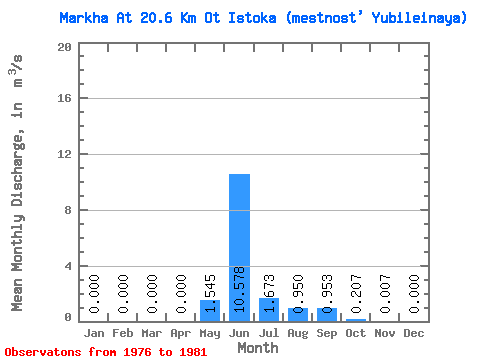
| Statistic | Jan | Feb | Mar | Apr | May | Jun | Jul | Aug | Sep | Oct | Nov | Dec | Annual |
|---|---|---|---|---|---|---|---|---|---|---|---|---|---|
| Mean | 0.00 | 0.00 | 0.00 | 0.00 | 1.54 | 10.58 | 1.67 | 0.95 | 0.95 | 0.21 | 0.01 | 0.00 | 1.33 |
| Standard Deviation | 0.00 | 0.00 | 0.00 | 0.00 | 2.55 | 4.47 | 0.94 | 0.73 | 0.44 | 0.09 | 0.01 | 0.00 | 0.32 |
| Min | 0.00 | 0.00 | 0.00 | 0.00 | 0.00 | 3.08 | 0.35 | 0.02 | 0.41 | 0.10 | 0.00 | 0.00 | 0.88 |
| Max | 0.00 | 0.00 | 0.00 | 0.00 | 6.09 | 15.60 | 2.40 | 1.96 | 1.65 | 0.34 | 0.01 | 0.00 | 1.64 |
| Coefficient of Variation | 1.65 | 0.42 | 0.56 | 0.77 | 0.46 | 0.45 | 0.82 | 0.24 |
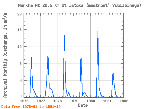
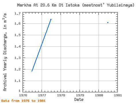
| Year | Jan | Feb | Mar | Apr | May | Jun | Jul | Aug | Sep | Oct | Nov | Dec | Annual | 1976 | 0.00 | 0.00 | 0.00 | 0.00 | 0.03 | 9.49 | 2.17 | 1.52 | 0.83 | 0.13 | 0.00 | 0.00 | 1.18 | 1977 | 0.00 | 0.00 | 0.00 | 0.00 | 3.13 | 10.40 | 2.24 | 1.96 | 1.65 | 0.24 | 0.01 | 0.00 | 1.64 | 1978 | 0.00 | 0.00 | 0.00 | 0.00 | 0.01 | 14.70 | 2.29 | 0.34 | 1.18 | 0.27 | 0.01 | 0.00 | 1.57 | 1979 | 0.00 | 0.00 | 0.00 | 0.00 | 0.00 | 10.20 | 0.35 | 1.14 | 1.01 | 0.34 | 0.01 | 0.00 | 1.09 | 1980 | 0.00 | 0.00 | 0.00 | 0.00 | 0.00 | 15.60 | 2.40 | 0.72 | 0.41 | 0.16 | 0.01 | 0.00 | 1.61 | 1981 | 0.00 | 0.00 | 0.00 | 0.00 | 6.09 | 3.08 | 0.59 | 0.02 | 0.64 | 0.10 | 0.00 | 0.00 | 0.88 |
|---|
 Return to R-Arctic Net Home Page