|
|
|||||||||||||||||
| Point ID: 7884 | Downloads | Plots | Site Data | Code: 3363 |
|
|
|||||||||||||||||
| Download | |
|---|---|
| Site Descriptor Information | Site Time Series Data |
| Link to all available data | |
|
|
| View: | Statistics | Time Series |
| Units: | mm |
| Statistic | Jan | Feb | Mar | Apr | May | Jun | Jul | Aug | Sep | Oct | Nov | Dec | Annual |
|---|---|---|---|---|---|---|---|---|---|---|---|---|---|
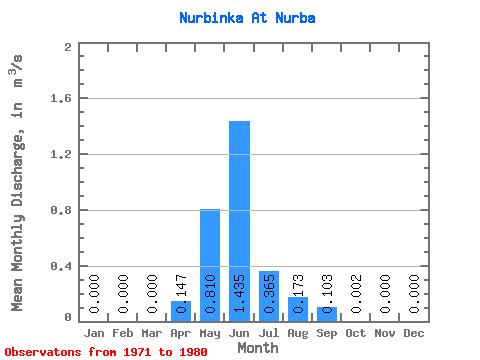
| Mean | 0.00 | 0.00 | 0.00 | 0.15 | 0.81 | 1.44 | 0.36 | 0.17 | 0.10 | 0.00 | 0.00 | 0.00 | 0.25 |
| Standard Deviation | 0.00 | 0.00 | 0.00 | 0.35 | 1.23 | 0.78 | 0.44 | 0.22 | 0.12 | 0.00 | 0.00 | 0.00 | 0.17 |
| Min | 0.00 | 0.00 | 0.00 | 0.00 | 0.00 | 0.13 | 0.00 | 0.00 | 0.00 | 0.00 | 0.00 | 0.00 | 0.06 |
| Max | 0.00 | 0.00 | 0.00 | 0.87 | 3.03 | 2.49 | 1.11 | 0.49 | 0.25 | 0.01 | 0.00 | 0.00 | 0.48 |
| Coefficient of Variation | 2.42 | 1.52 | 0.54 | 1.22 | 1.28 | 1.12 | 1.56 | 0.66 |
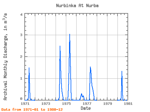
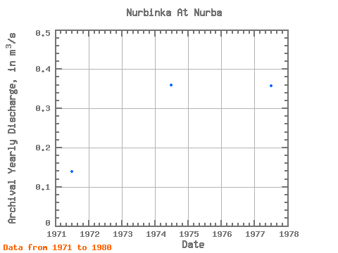
| Year | Jan | Feb | Mar | Apr | May | Jun | Jul | Aug | Sep | Oct | Nov | Dec | Annual | 1971 | 0.00 | 0.00 | 0.00 | 0.00 | 0.10 | 1.48 | 0.09 | 0.00 | 0.00 | 0.00 | 0.00 | 0.00 | 0.14 | 1974 | 0.00 | 0.00 | 0.00 | 0.00 | 0.12 | 2.49 | 1.11 | 0.41 | 0.17 | 0.00 | 0.00 | 0.00 | 0.36 | 1975 | 0.00 | 0.00 | 0.00 | 0.87 | 3.03 | 1.85 | 0.02 | 0.00 | 0.00 | 0.00 | 0.00 | 0.00 | 0.48 | 1976 | 0.00 | 0.00 | 0.00 | 0.00 | 0.00 | 0.13 | 0.29 | 0.14 | 0.20 | 0.01 | 0.00 | 0.00 | 0.06 | 1977 | 0.00 | 0.00 | 0.00 | 0.00 | 1.52 | 1.34 | 0.68 | 0.49 | 0.25 | 0.00 | 0.00 | 0.00 | 0.36 | 1980 | 0.00 | 0.00 | 0.00 | 0.01 | 0.09 | 1.32 | 0.00 | 0.00 | 0.00 | 0.00 | 0.00 | 0.00 | 0.12 |
|---|
 Return to R-Arctic Net Home Page