|
|
|||||||||||||||||
| Point ID: 7883 | Downloads | Plots | Site Data | Code: 3361 |
|
|
|||||||||||||||||
| Download | |
|---|---|
| Site Descriptor Information | Site Time Series Data |
| Link to all available data | |
|
|
| View: | Statistics | Time Series |
| Units: | mm |
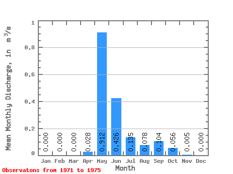
| Statistic | Jan | Feb | Mar | Apr | May | Jun | Jul | Aug | Sep | Oct | Nov | Dec | Annual |
|---|---|---|---|---|---|---|---|---|---|---|---|---|---|
| Mean | 0.00 | 0.00 | 0.00 | 0.03 | 0.91 | 0.43 | 0.14 | 0.08 | 0.10 | 0.06 | 0.01 | 0.00 | 0.13 |
| Standard Deviation | 0.00 | 0.00 | 0.00 | 0.06 | 0.39 | 0.42 | 0.12 | 0.06 | 0.10 | 0.06 | 0.01 | 0.00 | 0.07 |
| Min | 0.00 | 0.00 | 0.00 | 0.00 | 0.45 | 0.08 | 0.04 | 0.04 | 0.03 | 0.01 | 0.00 | 0.00 | 0.06 |
| Max | 0.00 | 0.00 | 0.00 | 0.14 | 1.51 | 1.05 | 0.32 | 0.17 | 0.25 | 0.15 | 0.02 | 0.00 | 0.22 |
| Coefficient of Variation | 2.24 | 0.43 | 0.99 | 0.93 | 0.82 | 0.96 | 1.15 | 1.91 | 0.53 |
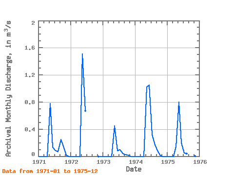
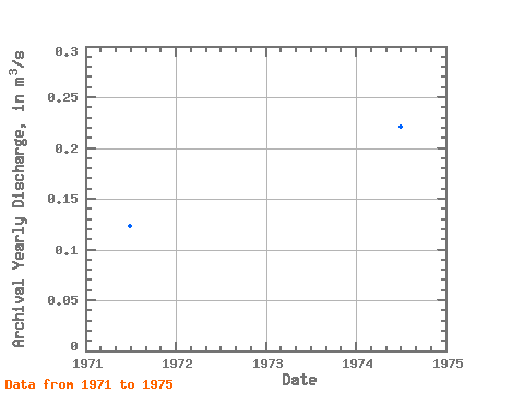
| Year | Jan | Feb | Mar | Apr | May | Jun | Jul | Aug | Sep | Oct | Nov | Dec | Annual | 1971 | 0.00 | 0.00 | 0.00 | 0.00 | 0.78 | 0.13 | 0.08 | 0.07 | 0.25 | 0.15 | 0.02 | 0.00 | 0.12 | 1972 | 0.00 | 0.00 | 0.00 | 0.00 | 1.51 | 0.67 | 0.00 | 0.00 | 1973 | 0.00 | 0.00 | 0.00 | 0.00 | 0.45 | 0.08 | 0.10 | 0.04 | 0.03 | 0.02 | 0.00 | 0.00 | 0.06 | 1974 | 0.00 | 0.00 | 0.00 | 0.00 | 1.02 | 1.05 | 0.32 | 0.17 | 0.09 | 0.01 | 0.00 | 0.00 | 0.22 | 1975 | 0.00 | 0.00 | 0.00 | 0.14 | 0.80 | 0.20 | 0.04 | 0.04 | 0.05 | 0.04 | 0.00 | 0.00 | 0.11 |
|---|
 Return to R-Arctic Net Home Page