|
|
|||||||||||||||||
| Point ID: 7878 | Downloads | Plots | Site Data | Code: 3350 |
|
|
|||||||||||||||||
| Download | |
|---|---|
| Site Descriptor Information | Site Time Series Data |
| Link to all available data | |
|
|
| View: | Statistics | Time Series |
| Units: | mm |
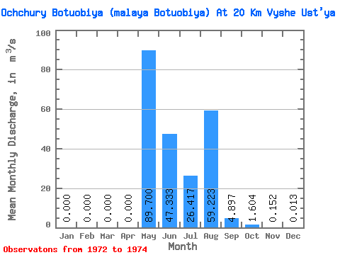
| Statistic | Jan | Feb | Mar | Apr | May | Jun | Jul | Aug | Sep | Oct | Nov | Dec | Annual |
|---|---|---|---|---|---|---|---|---|---|---|---|---|---|
| Mean | 0.00 | 0.00 | 0.00 | 0.00 | 89.70 | 47.33 | 26.42 | 59.22 | 4.90 | 1.60 | 0.15 | 0.01 | 19.11 |
| Standard Deviation | 0.00 | 0.00 | 0.00 | 0.00 | 59.45 | 43.39 | 29.15 | 97.70 | 3.42 | 0.98 | 0.13 | 0.01 | 10.23 |
| Min | 0.00 | 0.00 | 0.00 | 0.00 | 49.60 | 11.30 | 1.35 | 0.46 | 1.04 | 0.63 | 0.01 | 0.00 | 7.36 |
| Max | 0.00 | 0.00 | 0.00 | 0.00 | 158.00 | 95.50 | 58.40 | 172.00 | 7.57 | 2.60 | 0.25 | 0.02 | 26.05 |
| Coefficient of Variation | 0.66 | 0.92 | 1.10 | 1.65 | 0.70 | 0.61 | 0.85 | 0.90 | 0.54 |
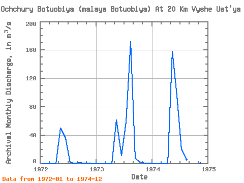
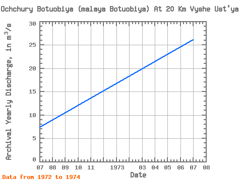
| Year | Jan | Feb | Mar | Apr | May | Jun | Jul | Aug | Sep | Oct | Nov | Dec | Annual | 1972 | 0.00 | 0.00 | 0.00 | 0.00 | 49.60 | 35.20 | 1.35 | 0.46 | 1.04 | 0.63 | 0.01 | 0.00 | 7.36 | 1973 | 0.00 | 0.00 | 0.00 | 0.00 | 61.50 | 11.30 | 58.40 | 172.00 | 7.57 | 1.58 | 0.20 | 0.02 | 26.05 | 1974 | 0.00 | 0.00 | 0.00 | 0.00 | 158.00 | 95.50 | 19.50 | 5.21 | 6.08 | 2.60 | 0.25 | 0.02 | 23.93 |
|---|
 Return to R-Arctic Net Home Page