|
|
|||||||||||||||||
| Point ID: 7870 | Downloads | Plots | Site Data | Code: 3339 |
|
|
|||||||||||||||||
| Download | |
|---|---|
| Site Descriptor Information | Site Time Series Data |
| Link to all available data | |
|
|
| View: | Statistics | Time Series |
| Units: | mm |
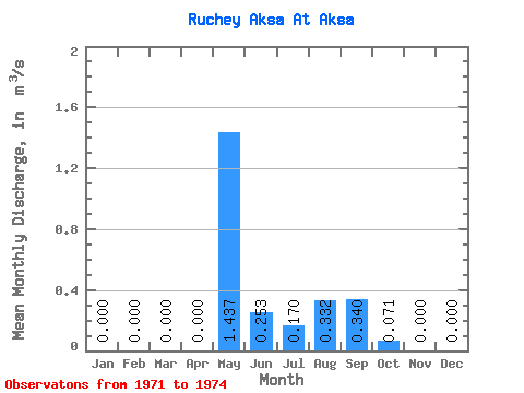
| Statistic | Jan | Feb | Mar | Apr | May | Jun | Jul | Aug | Sep | Oct | Nov | Dec | Annual |
|---|---|---|---|---|---|---|---|---|---|---|---|---|---|
| Mean | 0.00 | 0.00 | 0.00 | 0.00 | 1.44 | 0.25 | 0.17 | 0.33 | 0.34 | 0.07 | 0.00 | 0.00 | 0.20 |
| Standard Deviation | 0.00 | 0.00 | 0.00 | 0.00 | 0.75 | 0.19 | 0.29 | 0.27 | 0.15 | 0.06 | 0.00 | 0.00 | 0.12 |
| Min | 0.00 | 0.00 | 0.00 | 0.00 | 0.48 | 0.05 | 0.00 | 0.07 | 0.17 | 0.01 | 0.00 | 0.00 | 0.08 |
| Max | 0.00 | 0.00 | 0.00 | 0.00 | 2.04 | 0.42 | 0.51 | 0.60 | 0.46 | 0.13 | 0.00 | 0.00 | 0.32 |
| Coefficient of Variation | 0.52 | 0.74 | 1.73 | 0.81 | 0.45 | 0.84 | 0.59 |
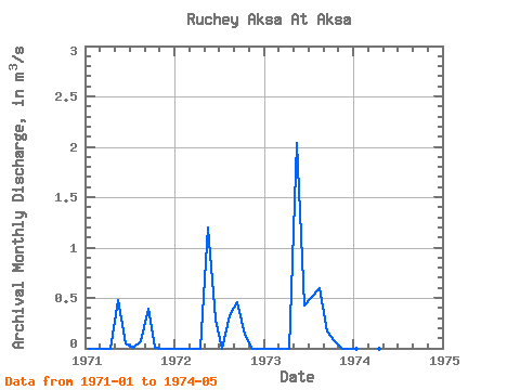
| Year | Jan | Feb | Mar | Apr | May | Jun | Jul | Aug | Sep | Oct | Nov | Dec | Annual | 1971 | 0.00 | 0.00 | 0.00 | 0.00 | 0.48 | 0.05 | 0.00 | 0.07 | 0.39 | 0.01 | 0.00 | 0.00 | 0.08 | 1972 | 0.00 | 0.00 | 0.00 | 0.00 | 1.20 | 0.29 | 0.00 | 0.33 | 0.46 | 0.13 | 0.00 | 0.00 | 0.20 | 1973 | 0.00 | 0.00 | 0.00 | 0.00 | 2.04 | 0.42 | 0.51 | 0.60 | 0.17 | 0.07 | 0.00 | 0.00 | 0.32 | 1974 | 0.00 | 0.00 | 0.00 | 0.00 | 2.03 |
|---|
 Return to R-Arctic Net Home Page