|
|
|||||||||||||||||
| Point ID: 7865 | Downloads | Plots | Site Data | Code: 3331 |
|
|
|||||||||||||||||
| Download | |
|---|---|
| Site Descriptor Information | Site Time Series Data |
| Link to all available data | |

|
|
| View: | Statistics | Time Series |
| Units: | mm |
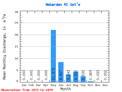
| Statistic | Jan | Feb | Mar | Apr | May | Jun | Jul | Aug | Sep | Oct | Nov | Dec | Annual |
|---|---|---|---|---|---|---|---|---|---|---|---|---|---|
| Mean | 0.00 | 0.00 | 0.00 | 0.00 | 21.97 | 8.41 | 3.24 | 4.51 | 2.53 | 0.37 | 0.03 | 0.00 | 3.42 |
| Standard Deviation | 0.00 | 0.00 | 0.00 | 0.00 | 7.60 | 4.29 | 3.99 | 6.90 | 3.38 | 0.26 | 0.04 | 0.01 | 0.73 |
| Min | 0.00 | 0.00 | 0.00 | 0.00 | 8.61 | 3.25 | 0.47 | 0.07 | 0.04 | 0.00 | 0.00 | 0.00 | 2.72 |
| Max | 0.00 | 0.00 | 0.00 | 0.00 | 31.90 | 14.00 | 10.40 | 17.60 | 9.63 | 0.65 | 0.09 | 0.01 | 4.78 |
| Coefficient of Variation | 0.35 | 0.51 | 1.23 | 1.53 | 1.33 | 0.71 | 1.13 | 2.45 | 0.21 |
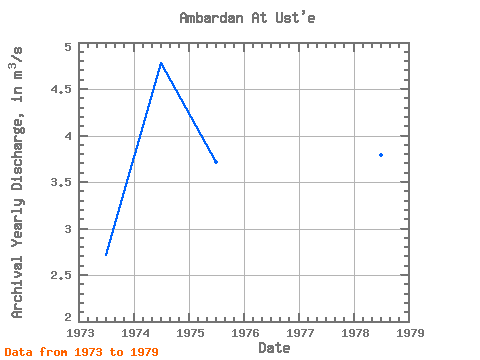
| Year | Jan | Feb | Mar | Apr | May | Jun | Jul | Aug | Sep | Oct | Nov | Dec | Annual | 1973 | 0.00 | 0.00 | 0.00 | 0.00 | 17.00 | 3.25 | 10.40 | 1.52 | 0.34 | 0.10 | 0.02 | 0.00 | 2.72 | 1974 | 0.00 | 0.00 | 0.00 | 0.00 | 21.80 | 7.18 | 7.40 | 10.70 | 9.63 | 0.55 | 0.09 | 0.01 | 4.78 | 1975 | 0.00 | 0.00 | 0.00 | 0.00 | 27.40 | 14.00 | 0.60 | 0.77 | 1.20 | 0.60 | 0.02 | 0.00 | 3.72 | 1976 | 0.00 | 0.00 | 0.00 | 0.00 | 8.61 | 4.63 | 1.31 | 17.60 | 3.42 | 0.48 | 0.00 | 0.00 | 3.00 | 1977 | 0.00 | 0.00 | 0.00 | 0.00 | 21.30 | 10.30 | 0.69 | 0.07 | 0.39 | 0.20 | 0.02 | 0.00 | 2.75 | 1978 | 0.00 | 0.00 | 0.00 | 0.00 | 25.80 | 13.60 | 1.83 | 0.84 | 2.70 | 0.65 | 0.08 | 0.00 | 3.79 | 1979 | 0.00 | 0.00 | 0.00 | 0.00 | 31.90 | 5.89 | 0.47 | 0.09 | 0.04 | 0.00 | 0.00 | 0.00 | 3.20 |
|---|
 Return to R-Arctic Net Home Page