|
|
|||||||||||||||||
| Point ID: 7858 | Downloads | Plots | Site Data | Code: 3289 |
|
|
|||||||||||||||||
| Download | |
|---|---|
| Site Descriptor Information | Site Time Series Data |
| Link to all available data | |
|
|
| View: | Statistics | Time Series |
| Units: | mm |
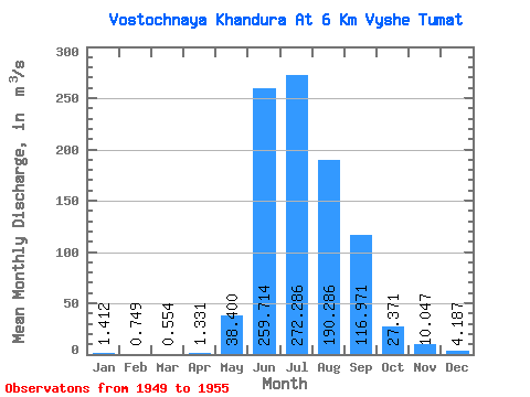
| Statistic | Jan | Feb | Mar | Apr | May | Jun | Jul | Aug | Sep | Oct | Nov | Dec | Annual |
|---|---|---|---|---|---|---|---|---|---|---|---|---|---|
| Mean | 1.41 | 0.75 | 0.55 | 1.33 | 38.40 | 259.71 | 272.29 | 190.29 | 116.97 | 27.37 | 10.05 | 4.19 | 76.94 |
| Standard Deviation | 0.63 | 0.32 | 0.28 | 0.49 | 19.37 | 152.41 | 89.60 | 57.02 | 72.61 | 9.83 | 1.79 | 1.28 | 23.15 |
| Min | 0.51 | 0.29 | 0.14 | 0.65 | 16.90 | 116.00 | 142.00 | 129.00 | 41.70 | 16.20 | 7.20 | 2.00 | 41.81 |
| Max | 2.20 | 1.16 | 0.90 | 2.22 | 62.40 | 485.00 | 403.00 | 276.00 | 216.00 | 41.60 | 12.70 | 5.66 | 111.59 |
| Coefficient of Variation | 0.45 | 0.42 | 0.52 | 0.36 | 0.51 | 0.59 | 0.33 | 0.30 | 0.62 | 0.36 | 0.18 | 0.31 | 0.30 |
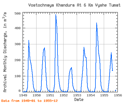
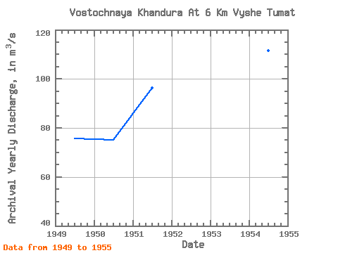
| Year | Jan | Feb | Mar | Apr | May | Jun | Jul | Aug | Sep | Oct | Nov | Dec | Annual | 1949 | 1.39 | 0.73 | 0.55 | 2.22 | 30.10 | 323.00 | 207.00 | 174.00 | 121.00 | 34.50 | 10.40 | 3.52 | 75.70 | 1950 | 1.47 | 1.16 | 0.83 | 1.55 | 16.90 | 163.00 | 261.00 | 276.00 | 135.00 | 29.00 | 10.80 | 4.87 | 75.13 | 1951 | 1.82 | 0.77 | 0.75 | 1.14 | 48.70 | 485.00 | 403.00 | 129.00 | 55.10 | 16.70 | 8.33 | 5.02 | 96.28 | 1952 | 2.20 | 1.09 | 0.90 | 1.38 | 17.10 | 116.00 | 142.00 | 154.00 | 41.70 | 16.20 | 7.20 | 2.00 | 41.81 | 1953 | 0.65 | 0.29 | 0.14 | 1.05 | 61.70 | 143.00 | 280.00 | 220.00 | 216.00 | 33.30 | 10.50 | 3.31 | 80.83 | 1954 | 0.51 | 0.43 | 0.31 | 0.65 | 31.90 | 433.00 | 367.00 | 244.00 | 202.00 | 41.60 | 12.70 | 4.93 | 111.59 | 1955 | 1.84 | 0.77 | 0.40 | 1.33 | 62.40 | 155.00 | 246.00 | 135.00 | 48.00 | 20.30 | 10.40 | 5.66 | 57.26 |
|---|
 Return to R-Arctic Net Home Page