|
|
|||||||||||||||||
| Point ID: 7840 | Downloads | Plots | Site Data | Code: 3243 |
|
|
|||||||||||||||||
| Download | |
|---|---|
| Site Descriptor Information | Site Time Series Data |
| Link to all available data | |
| View: | Time Series | All |
| Units: | m3/s |
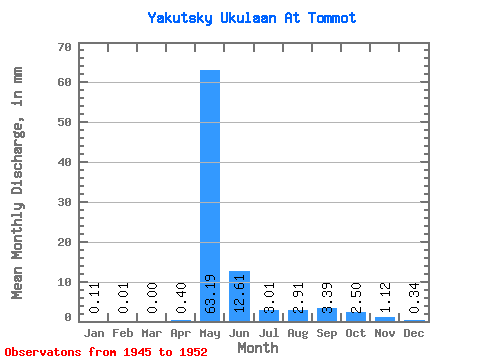
| Statistic | Jan | Feb | Mar | Apr | May | Jun | Jul | Aug | Sep | Oct | Nov | Dec | Annual |
|---|---|---|---|---|---|---|---|---|---|---|---|---|---|
| Mean | 0.12 | 0.01 | 0.00 | 0.40 | 63.18 | 12.61 | 3.00 | 2.91 | 3.39 | 2.51 | 1.12 | 0.34 | 85.71 |
| Standard Deviation | 0.26 | 0.03 | 0.00 | 0.58 | 21.02 | 11.33 | 2.55 | 1.98 | 2.55 | 1.77 | 0.77 | 0.41 | 35.44 |
| Min | 0.00 | 0.00 | 0.00 | 0.00 | 44.91 | 1.40 | 0.82 | 0.84 | 0.79 | 0.62 | 0.29 | 0.04 | 51.73 |
| Max | 0.59 | 0.07 | 0.00 | 1.30 | 98.88 | 28.71 | 7.83 | 5.97 | 7.38 | 5.46 | 2.39 | 1.13 | 145.84 |
| Coefficient of Variation | 2.24 | 2.24 | 1.48 | 0.33 | 0.90 | 0.85 | 0.68 | 0.75 | 0.71 | 0.69 | 1.19 | 0.41 |
 Return to R-Arctic Net Home Page