|
|
|||||||||||||||||
| Point ID: 7817 | Downloads | Plots | Site Data | Code: 3151 |
|
|
|||||||||||||||||
| Download | |
|---|---|
| Site Descriptor Information | Site Time Series Data |
| Link to all available data | |
|
|
| View: | Statistics | Time Series |
| Units: | mm |
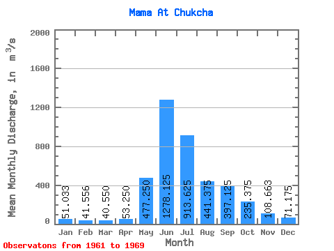
| Statistic | Jan | Feb | Mar | Apr | May | Jun | Jul | Aug | Sep | Oct | Nov | Dec | Annual |
|---|---|---|---|---|---|---|---|---|---|---|---|---|---|
| Mean | 51.03 | 41.56 | 40.55 | 53.25 | 477.25 | 1278.12 | 913.62 | 441.38 | 397.12 | 235.38 | 108.66 | 71.17 | 342.94 |
| Standard Deviation | 13.68 | 12.13 | 4.03 | 26.46 | 152.66 | 361.10 | 324.61 | 111.39 | 94.98 | 35.47 | 27.82 | 19.98 | 46.28 |
| Min | 24.10 | 18.80 | 33.10 | 35.00 | 277.00 | 877.00 | 472.00 | 277.00 | 284.00 | 189.00 | 84.60 | 39.40 | 287.90 |
| Max | 70.80 | 60.20 | 46.90 | 116.00 | 666.00 | 1980.00 | 1410.00 | 581.00 | 517.00 | 303.00 | 164.00 | 110.00 | 400.97 |
| Coefficient of Variation | 0.27 | 0.29 | 0.10 | 0.50 | 0.32 | 0.28 | 0.35 | 0.25 | 0.24 | 0.15 | 0.26 | 0.28 | 0.14 |
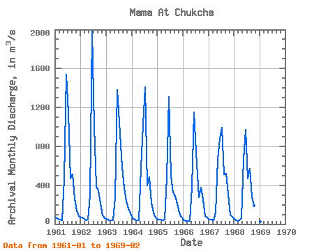
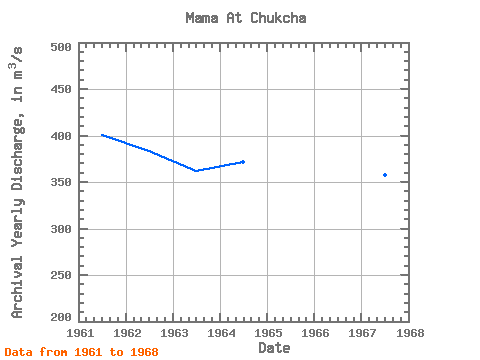
| Year | Jan | Feb | Mar | Apr | May | Jun | Jul | Aug | Sep | Oct | Nov | Dec | Annual | 1961 | 66.70 | 52.60 | 46.90 | 39.40 | 464.00 | 1540.00 | 1140.00 | 472.00 | 511.00 | 262.00 | 137.00 | 80.00 | 400.97 | 1962 | 70.80 | 60.20 | 41.00 | 43.20 | 296.00 | 1980.00 | 1010.00 | 389.00 | 344.00 | 214.00 | 93.00 | 60.70 | 383.49 | 1963 | 50.50 | 42.70 | 38.80 | 41.30 | 277.00 | 1380.00 | 1050.00 | 581.00 | 377.00 | 231.00 | 164.00 | 110.00 | 361.94 | 1964 | 59.30 | 46.00 | 43.00 | 42.10 | 580.00 | 1020.00 | 1410.00 | 400.00 | 481.00 | 219.00 | 92.50 | 62.20 | 371.26 | 1965 | 47.50 | 43.90 | 42.90 | 48.70 | 485.00 | 1310.00 | 488.00 | 327.00 | 284.00 | 215.00 | 110.00 | 74.00 | 289.67 | 1966 | 46.60 | 35.60 | 33.10 | 35.00 | 385.00 | 1150.00 | 743.00 | 277.00 | 377.00 | 250.00 | 84.60 | 70.70 | 290.63 | 1967 | 46.70 | 43.70 | 39.70 | 116.00 | 666.00 | 877.00 | 996.00 | 516.00 | 517.00 | 303.00 | 98.70 | 72.40 | 357.68 | 1968 | 47.10 | 30.50 | 39.00 | 60.30 | 665.00 | 968.00 | 472.00 | 569.00 | 286.00 | 189.00 | 89.50 | 39.40 | 287.90 | 1969 | 24.10 | 18.80 |
|---|
 Return to R-Arctic Net Home Page