|
|
|||||||||||||||||
| Point ID: 7776 | Downloads | Plots | Site Data | Code: 10PB002 |
|
|
|||||||||||||||||
| Download | |
|---|---|
| Site Descriptor Information | Site Time Series Data |
| Link to all available data | |
|
|
| View: | Statistics | Time Series |
| Units: | mm |
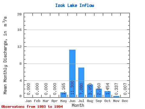
| Statistic | Jan | Feb | Mar | Apr | May | Jun | Jul | Aug | Sep | Oct | Nov | Dec | Annual |
|---|---|---|---|---|---|---|---|---|---|---|---|---|---|
| Mean | 0.00 | 0.00 | 0.00 | 0.00 | 1.17 | 11.30 | 7.08 | 3.05 | 2.06 | 1.45 | 0.34 | 0.01 | 2.20 |
| Standard Deviation | 0.00 | 0.00 | 0.00 | 0.00 | 1.65 | 1.56 | 6.67 | 2.98 | 0.54 | 0.84 | 0.26 | 0.01 | 0.75 |
| Min | 0.00 | 0.00 | 0.00 | 0.00 | 0.00 | 10.20 | 2.36 | 0.94 | 1.68 | 0.86 | 0.16 | 0.00 | 1.67 |
| Max | 0.00 | 0.00 | 0.00 | 0.00 | 2.33 | 12.40 | 11.80 | 5.16 | 2.44 | 2.05 | 0.52 | 0.01 | 2.73 |
| Coefficient of Variation | 1.41 | 0.14 | 0.94 | 0.98 | 0.26 | 0.58 | 0.76 | 1.41 | 0.34 |
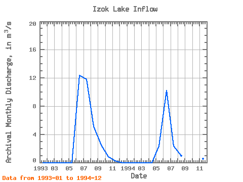
| Year | Jan | Feb | Mar | Apr | May | Jun | Jul | Aug | Sep | Oct | Nov | Dec | Annual | 1993 | 0.00 | 0.00 | 0.00 | 0.00 | 0.00 | 12.40 | 11.80 | 5.16 | 2.44 | 0.86 | 0.16 | 0.00 | 2.73 | 1994 | 0.00 | 0.00 | 0.00 | 0.00 | 2.33 | 10.20 | 2.36 | 0.94 | 1.68 | 2.05 | 0.52 | 0.01 | 1.67 |
|---|
 Return to R-Arctic Net Home Page