|
|
|||||||||||||||||
| Point ID: 7772 | Downloads | Plots | Site Data | Code: 10ED009 |
|
|
|||||||||||||||||
| Download | |
|---|---|
| Site Descriptor Information | Site Time Series Data |
| Link to all available data | |
|
|
| View: | Statistics | Time Series |
| Units: | mm |
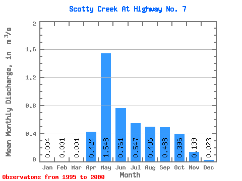
| Statistic | Jan | Feb | Mar | Apr | May | Jun | Jul | Aug | Sep | Oct | Nov | Dec | Annual |
|---|---|---|---|---|---|---|---|---|---|---|---|---|---|
| Mean | 0.00 | 0.00 | 0.00 | 0.42 | 1.55 | 0.76 | 0.55 | 0.50 | 0.49 | 0.40 | 0.14 | 0.02 | 0.40 |
| Standard Deviation | 0.00 | 0.00 | 0.00 | 0.38 | 0.67 | 0.60 | 0.50 | 0.62 | 0.52 | 0.24 | 0.13 | 0.02 | 0.20 |
| Min | 0.00 | 0.00 | 0.00 | 0.01 | 0.62 | 0.04 | 0.00 | 0.00 | 0.00 | 0.00 | 0.00 | 0.00 | 0.11 |
| Max | 0.01 | 0.00 | 0.00 | 1.05 | 2.33 | 1.62 | 1.17 | 1.74 | 1.22 | 0.73 | 0.37 | 0.05 | 0.66 |
| Coefficient of Variation | 1.08 | 0.78 | 1.09 | 0.90 | 0.43 | 0.79 | 0.92 | 1.25 | 1.05 | 0.59 | 0.95 | 0.90 | 0.50 |
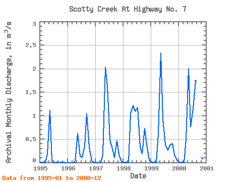
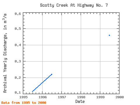
| Year | Jan | Feb | Mar | Apr | May | Jun | Jul | Aug | Sep | Oct | Nov | Dec | Annual | 1995 | 0.00 | 0.00 | 0.00 | 0.19 | 1.11 | 0.04 | 0.00 | 0.00 | 0.00 | 0.00 | 0.00 | 0.00 | 0.11 | 1996 | 0.00 | 0.00 | 0.00 | 0.01 | 0.62 | 0.13 | 0.11 | 0.35 | 1.04 | 0.33 | 0.04 | 0.00 | 0.22 | 1997 | 0.00 | 0.00 | 0.00 | 0.18 | 2.03 | 1.62 | 0.47 | 0.30 | 0.10 | 0.47 | 0.16 | 0.02 | 0.45 | 1998 | 0.00 | 0.00 | 0.00 | 1.05 | 1.21 | 1.09 | 1.17 | 0.33 | 0.19 | 0.73 | 0.37 | 0.05 | 0.52 | 1999 | 0.01 | 0.00 | 0.00 | 0.62 | 2.33 | 0.92 | 0.38 | 0.27 | 0.38 | 0.40 | 0.17 | 0.05 | 0.46 | 2000 | 0.01 | 0.00 | 0.00 | 0.49 | 1.99 | 0.76 | 1.14 | 1.74 | 1.22 | 0.45 | 0.09 | 0.03 | 0.66 |
|---|
 Return to R-Arctic Net Home Page