|
|
|||||||||||||||||
| Point ID: 7771 | Downloads | Plots | Site Data | Code: 10DA001 |
|
|
|||||||||||||||||
| Download | |
|---|---|
| Site Descriptor Information | Site Time Series Data |
| Link to all available data | |
|
|
| View: | Statistics | Time Series |
| Units: | mm |
| Statistic | Jan | Feb | Mar | Apr | May | Jun | Jul | Aug | Sep | Oct | Nov | Dec | Annual |
|---|---|---|---|---|---|---|---|---|---|---|---|---|---|
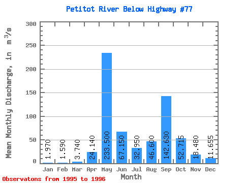
| Mean | 1.97 | 1.59 | 3.74 | 24.14 | 233.50 | 67.15 | 32.95 | 46.60 | 142.63 | 52.72 | 18.48 | 11.65 | 53.09 |
| Standard Deviation | 0.24 | 0.16 | 4.21 | 28.09 | 64.35 | 34.72 | 28.21 | 41.44 | 188.61 | 62.91 | 18.41 | 12.51 | 35.60 |
| Min | 1.80 | 1.48 | 0.76 | 4.28 | 188.00 | 42.60 | 13.00 | 17.30 | 9.26 | 8.23 | 5.46 | 2.81 | 27.92 |
| Max | 2.14 | 1.70 | 6.72 | 44.00 | 279.00 | 91.70 | 52.90 | 75.90 | 276.00 | 97.20 | 31.50 | 20.50 | 78.27 |
| Coefficient of Variation | 0.12 | 0.10 | 1.13 | 1.16 | 0.28 | 0.52 | 0.86 | 0.89 | 1.32 | 1.19 | 1.00 | 1.07 | 0.67 |
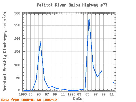
| Year | Jan | Feb | Mar | Apr | May | Jun | Jul | Aug | Sep | Oct | Nov | Dec | Annual | 1995 | 2.14 | 1.48 | 0.76 | 44.00 | 188.00 | 42.60 | 13.00 | 17.30 | 9.26 | 8.23 | 5.46 | 2.81 | 27.92 | 1996 | 1.80 | 1.70 | 6.72 | 4.28 | 279.00 | 91.70 | 52.90 | 75.90 | 276.00 | 97.20 | 31.50 | 20.50 | 78.27 |
|---|
 Return to R-Arctic Net Home Page