|
|
|||||||||||||||||
| Point ID: 7769 | Downloads | Plots | Site Data | Code: 09DB001 |
|
|
|||||||||||||||||
| Download | |
|---|---|
| Site Descriptor Information | Site Time Series Data |
| Link to all available data | |
|
|
| View: | Statistics | Time Series |
| Units: | mm |
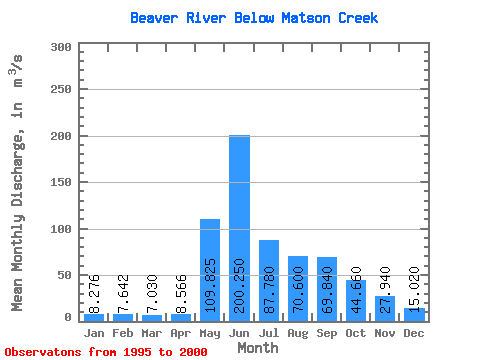
| Statistic | Jan | Feb | Mar | Apr | May | Jun | Jul | Aug | Sep | Oct | Nov | Dec | Annual |
|---|---|---|---|---|---|---|---|---|---|---|---|---|---|
| Mean | 8.28 | 7.64 | 7.03 | 8.57 | 109.83 | 200.25 | 87.78 | 70.60 | 69.84 | 44.66 | 27.94 | 15.02 | 56.47 |
| Standard Deviation | 2.71 | 1.83 | 1.16 | 1.80 | 35.35 | 101.00 | 43.34 | 27.63 | 15.48 | 10.65 | 8.46 | 3.23 | 14.91 |
| Min | 4.14 | 5.22 | 5.61 | 5.97 | 73.50 | 123.00 | 55.90 | 44.40 | 48.40 | 30.80 | 16.50 | 10.30 | 43.04 |
| Max | 11.30 | 9.39 | 8.34 | 11.00 | 150.00 | 345.00 | 163.00 | 121.00 | 91.50 | 60.70 | 39.30 | 18.60 | 76.75 |
| Coefficient of Variation | 0.33 | 0.24 | 0.17 | 0.21 | 0.32 | 0.50 | 0.49 | 0.39 | 0.22 | 0.24 | 0.30 | 0.21 | 0.26 |
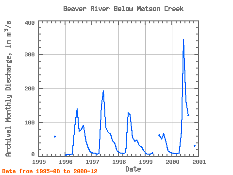
| Year | Jan | Feb | Mar | Apr | May | Jun | Jul | Aug | Sep | Oct | Nov | Dec | Annual | 1995 | 58.20 | 1996 | 4.14 | 5.22 | 5.61 | 5.97 | 87.80 | 140.00 | 74.20 | 79.00 | 91.50 | 44.70 | 23.80 | 13.40 | 47.95 | 1997 | 9.76 | 8.95 | 6.95 | 8.25 | 150.00 | 193.00 | 83.20 | 69.50 | 67.90 | 44.60 | 39.30 | 16.20 | 58.13 | 1998 | 11.30 | 9.39 | 8.03 | 11.00 | 128.00 | 123.00 | 55.90 | 44.40 | 48.40 | 30.80 | 29.70 | 16.60 | 43.04 | 1999 | 7.40 | 6.19 | 6.22 | 8.61 | 62.60 | 51.50 | 67.20 | 42.50 | 16.50 | 10.30 | 2000 | 8.78 | 8.46 | 8.34 | 9.00 | 73.50 | 345.00 | 163.00 | 121.00 | 74.20 | 60.70 | 30.40 | 18.60 | 76.75 |
|---|
 Return to R-Arctic Net Home Page