|
|
|||||||||||||||||
| Point ID: 7765 | Downloads | Plots | Site Data | Code: 07QD007 |
|
|
|||||||||||||||||
| Download | |
|---|---|
| Site Descriptor Information | Site Time Series Data |
| Link to all available data | |
|
|
| View: | Statistics | Time Series |
| Units: | mm |
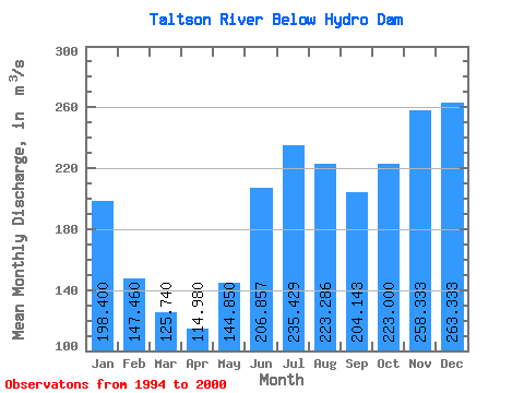
| Statistic | Jan | Feb | Mar | Apr | May | Jun | Jul | Aug | Sep | Oct | Nov | Dec | Annual |
|---|---|---|---|---|---|---|---|---|---|---|---|---|---|
| Mean | 198.40 | 147.46 | 125.74 | 114.98 | 144.85 | 206.86 | 235.43 | 223.29 | 204.14 | 223.00 | 258.33 | 263.33 | 198.98 |
| Standard Deviation | 85.75 | 37.22 | 24.93 | 26.57 | 56.76 | 80.06 | 69.56 | 56.11 | 40.17 | 73.12 | 99.54 | 117.69 | 21.71 |
| Min | 109.00 | 99.30 | 91.70 | 85.90 | 92.70 | 122.00 | 149.00 | 168.00 | 155.00 | 131.00 | 126.00 | 122.00 | 166.38 |
| Max | 339.00 | 200.00 | 158.00 | 156.00 | 246.00 | 326.00 | 342.00 | 328.00 | 252.00 | 330.00 | 409.00 | 468.00 | 227.08 |
| Coefficient of Variation | 0.43 | 0.25 | 0.20 | 0.23 | 0.39 | 0.39 | 0.29 | 0.25 | 0.20 | 0.33 | 0.39 | 0.45 | 0.11 |
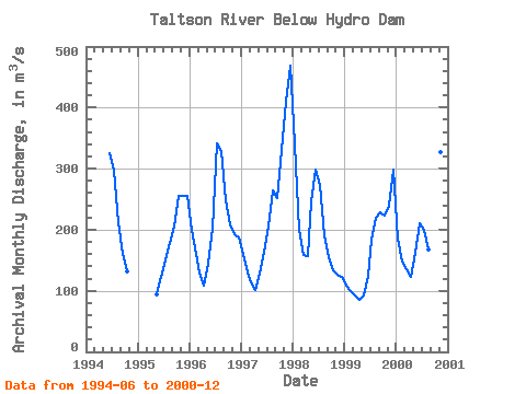
| Year | Jan | Feb | Mar | Apr | May | Jun | Jul | Aug | Sep | Oct | Nov | Dec | Annual | 1994 | 326.00 | 297.00 | 213.00 | 160.00 | 131.00 | 1995 | 94.40 | 122.00 | 149.00 | 179.00 | 205.00 | 255.00 | 255.00 | 256.00 | 1996 | 199.00 | 160.00 | 130.00 | 109.00 | 145.00 | 202.00 | 342.00 | 328.00 | 248.00 | 209.00 | 193.00 | 187.00 | 204.33 | 1997 | 160.00 | 130.00 | 113.00 | 101.00 | 128.00 | 164.00 | 205.00 | 265.00 | 252.00 | 330.00 | 409.00 | 468.00 | 227.08 | 1998 | 339.00 | 200.00 | 158.00 | 156.00 | 246.00 | 299.00 | 273.00 | 191.00 | 155.00 | 134.00 | 126.00 | 122.00 | 199.92 | 1999 | 109.00 | 99.30 | 91.70 | 85.90 | 92.70 | 125.00 | 183.00 | 219.00 | 228.00 | 224.00 | 240.00 | 299.00 | 166.38 | 2000 | 185.00 | 148.00 | 136.00 | 123.00 | 163.00 | 210.00 | 199.00 | 168.00 | 181.00 | 278.00 | 327.00 | 248.00 | 197.17 |
|---|
 Return to R-Arctic Net Home Page