|
|
|||||||||||||||||
| Point ID: 773 | Downloads | Plots | Site Data | Code: 07GJ001 |
|
|
|||||||||||||||||
| Download | |
|---|---|
| Site Descriptor Information | Site Time Series Data |
| Link to all available data | |
|
|
| View: | Statistics | Time Series |
| Units: | mm |
| Statistic | Jan | Feb | Mar | Apr | May | Jun | Jul | Aug | Sep | Oct | Nov | Dec | Annual |
|---|---|---|---|---|---|---|---|---|---|---|---|---|---|
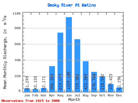
| Mean | 51.25 | 43.13 | 52.17 | 356.32 | 819.08 | 1029.18 | 729.35 | 423.39 | 276.70 | 218.54 | 109.42 | 62.20 | 347.48 |
| Standard Deviation | 21.85 | 12.60 | 31.20 | 204.90 | 334.91 | 364.93 | 322.62 | 254.33 | 133.32 | 99.16 | 44.19 | 21.68 | 89.40 |
| Min | 22.90 | 22.20 | 21.90 | 79.80 | 289.00 | 425.00 | 260.00 | 162.00 | 107.00 | 80.70 | 43.60 | 24.70 | 186.64 |
| Max | 158.00 | 83.80 | 236.00 | 900.00 | 1890.00 | 2070.00 | 1660.00 | 1200.00 | 653.00 | 475.00 | 305.00 | 142.00 | 584.76 |
| Coefficient of Variation | 0.43 | 0.29 | 0.60 | 0.57 | 0.41 | 0.35 | 0.44 | 0.60 | 0.48 | 0.45 | 0.40 | 0.35 | 0.26 |
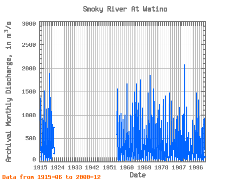
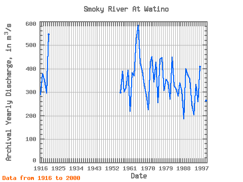
| Year | Jan | Feb | Mar | Apr | May | Jun | Jul | Aug | Sep | Oct | Nov | Dec | Annual | 1915 | 873.00 | 1360.00 | 464.00 | 241.00 | 213.00 | 93.00 | 46.30 | 1916 | 33.30 | 48.20 | 52.60 | 197.00 | 444.00 | 785.00 | 926.00 | 342.00 | 242.00 | 220.00 | 132.00 | 57.40 | 289.96 | 1917 | 43.30 | 36.90 | 31.80 | 279.00 | 1510.00 | 1260.00 | 567.00 | 286.00 | 167.00 | 191.00 | 106.00 | 57.40 | 377.95 | 1918 | 90.70 | 57.00 | 41.70 | 311.00 | 561.00 | 1120.00 | 1050.00 | 436.00 | 239.00 | 149.00 | 79.50 | 59.80 | 349.56 | 1919 | 41.70 | 23.30 | 23.50 | 186.00 | 311.00 | 1130.00 | 607.00 | 414.00 | 455.00 | 197.00 | 87.10 | 71.60 | 295.60 | 1920 | 66.80 | 47.60 | 43.10 | 130.00 | 1890.00 | 1680.00 | 1070.00 | 568.00 | 406.00 | 424.00 | 149.00 | 67.50 | 545.17 | 1921 | 57.50 | 45.70 | 72.90 | 491.00 | 1060.00 | 1070.00 | 526.00 | 405.00 | 301.00 | 294.00 | 1922 | 724.00 | 357.00 | 261.00 | 182.00 | 1955 | 590.00 | 1550.00 | 939.00 | 462.00 | 158.00 | 96.00 | 51.90 | 37.80 | 1956 | 29.40 | 27.60 | 28.10 | 556.00 | 690.00 | 989.00 | 368.00 | 339.00 | 206.00 | 168.00 | 120.00 | 52.10 | 297.77 | 1957 | 35.10 | 24.00 | 29.70 | 363.00 | 1030.00 | 653.00 | 597.00 | 841.00 | 335.00 | 309.00 | 305.00 | 142.00 | 388.65 | 1958 | 158.00 | 48.20 | 38.90 | 418.00 | 902.00 | 846.00 | 542.00 | 176.00 | 154.00 | 194.00 | 77.70 | 43.40 | 299.85 | 1959 | 35.80 | 29.20 | 37.60 | 170.00 | 605.00 | 994.00 | 574.00 | 305.00 | 447.00 | 295.00 | 220.00 | 127.00 | 319.97 | 1960 | 59.70 | 43.00 | 84.60 | 341.00 | 859.00 | 1660.00 | 927.00 | 305.00 | 143.00 | 138.00 | 79.00 | 68.90 | 392.35 | 1961 | 46.70 | 30.10 | 34.40 | 86.50 | 482.00 | 642.00 | 450.00 | 204.00 | 171.00 | 286.00 | 144.00 | 40.20 | 218.07 | 1962 | 31.10 | 47.70 | 21.90 | 566.00 | 1000.00 | 940.00 | 834.00 | 420.00 | 340.00 | 181.00 | 136.00 | 64.30 | 381.83 | 1963 | 61.80 | 54.20 | 68.50 | 721.00 | 1250.00 | 988.00 | 475.00 | 266.00 | 227.00 | 170.00 | 89.90 | 63.40 | 369.57 | 1964 | 45.80 | 49.30 | 36.20 | 184.00 | 890.00 | 1490.00 | 1050.00 | 1200.00 | 653.00 | 475.00 | 143.00 | 77.10 | 524.45 | 1965 | 63.70 | 52.90 | 64.70 | 833.00 | 1200.00 | 1440.00 | 1660.00 | 540.00 | 511.00 | 418.00 | 170.00 | 63.80 | 584.76 | 1966 | 60.30 | 52.40 | 58.80 | 660.00 | 1250.00 | 871.00 | 691.00 | 645.00 | 376.00 | 216.00 | 117.00 | 74.90 | 422.70 | 1967 | 64.90 | 58.80 | 49.10 | 155.00 | 1280.00 | 1750.00 | 593.00 | 317.00 | 164.00 | 129.00 | 66.80 | 47.90 | 389.62 | 1968 | 50.50 | 57.90 | 84.60 | 152.00 | 727.00 | 1140.00 | 683.00 | 480.00 | 279.00 | 165.00 | 108.00 | 45.70 | 331.06 | 1969 | 36.10 | 31.20 | 31.60 | 469.00 | 696.00 | 605.00 | 339.00 | 368.00 | 464.00 | 240.00 | 89.00 | 68.60 | 286.46 | 1970 | 38.50 | 35.50 | 48.60 | 373.00 | 528.00 | 770.00 | 344.00 | 223.00 | 133.00 | 112.00 | 46.00 | 37.20 | 224.07 | 1971 | 31.10 | 31.50 | 29.40 | 331.00 | 683.00 | 1470.00 | 1450.00 | 344.00 | 224.00 | 315.00 | 129.00 | 72.90 | 425.91 | 1972 | 50.70 | 38.20 | 66.50 | 476.00 | 1140.00 | 1840.00 | 572.00 | 366.00 | 196.00 | 411.00 | 159.00 | 94.10 | 450.79 | 1973 | 86.40 | 67.00 | 55.80 | 523.00 | 995.00 | 905.00 | 464.00 | 297.00 | 197.00 | 276.00 | 149.00 | 92.00 | 342.27 | 1974 | 59.60 | 54.90 | 46.80 | 900.00 | 1550.00 | 1030.00 | 598.00 | 298.00 | 217.00 | 242.00 | 71.50 | 45.20 | 426.08 | 1975 | 46.50 | 33.10 | 32.50 | 156.00 | 500.00 | 777.00 | 807.00 | 252.00 | 172.00 | 111.00 | 127.00 | 54.70 | 255.73 | 1976 | 50.30 | 52.00 | 41.30 | 554.00 | 890.00 | 915.00 | 807.00 | 1100.00 | 493.00 | 219.00 | 101.00 | 66.10 | 440.73 | 1977 | 68.60 | 65.10 | 54.30 | 526.00 | 1220.00 | 1100.00 | 889.00 | 525.00 | 348.00 | 389.00 | 101.00 | 76.10 | 446.84 | 1978 | 46.80 | 42.30 | 58.70 | 213.00 | 549.00 | 874.00 | 605.00 | 297.00 | 460.00 | 275.00 | 182.00 | 75.90 | 306.56 | 1979 | 45.80 | 38.90 | 52.10 | 259.00 | 1060.00 | 1330.00 | 861.00 | 267.00 | 152.00 | 115.00 | 43.60 | 24.70 | 354.09 | 1980 | 28.00 | 25.50 | 28.80 | 259.00 | 576.00 | 1400.00 | 624.00 | 315.00 | 384.00 | 256.00 | 114.00 | 86.70 | 341.42 | 1981 | 79.60 | 83.80 | 87.20 | 355.00 | 837.00 | 690.00 | 431.00 | 331.00 | 136.00 | 80.70 | 91.40 | 28.80 | 269.29 | 1982 | 22.90 | 28.90 | 37.70 | 108.00 | 881.00 | 992.00 | 1470.00 | 1030.00 | 452.00 | 223.00 | 84.60 | 57.80 | 448.99 | 1983 | 47.70 | 38.20 | 38.90 | 223.00 | 469.00 | 859.00 | 1300.00 | 409.00 | 214.00 | 137.00 | 117.00 | 58.20 | 325.92 | 1984 | 47.10 | 47.10 | 50.40 | 188.00 | 650.00 | 932.00 | 523.00 | 264.00 | 480.00 | 383.00 | 132.00 | 58.90 | 312.96 | 1985 | 51.20 | 42.60 | 59.20 | 355.00 | 600.00 | 680.00 | 435.00 | 251.00 | 402.00 | 346.00 | 110.00 | 70.70 | 283.56 | 1986 | 49.30 | 39.10 | 70.30 | 351.00 | 827.00 | 968.00 | 840.00 | 293.00 | 169.00 | 296.00 | 94.90 | 75.60 | 339.43 | 1987 | 60.20 | 47.90 | 41.90 | 266.00 | 607.00 | 670.00 | 348.00 | 1160.00 | 227.00 | 112.00 | 105.00 | 45.10 | 307.51 | 1988 | 32.40 | 32.70 | 54.80 | 171.00 | 393.00 | 658.00 | 443.00 | 175.00 | 107.00 | 92.60 | 52.10 | 28.10 | 186.64 | 1989 | 24.40 | 22.20 | 24.80 | 115.00 | 775.00 | 985.00 | 973.00 | 1020.00 | 437.00 | 203.00 | 118.00 | 86.20 | 398.63 | 1990 | 85.60 | 54.70 | 90.90 | 255.00 | 664.00 | 2070.00 | 634.00 | 225.00 | 160.00 | 113.00 | 74.60 | 57.50 | 373.69 | 1991 | 39.40 | 43.30 | 49.30 | 437.00 | 1170.00 | 914.00 | 654.00 | 403.00 | 222.00 | 131.00 | 108.00 | 82.20 | 354.43 | 1992 | 62.20 | 62.50 | 236.00 | 415.00 | 571.00 | 623.00 | 260.00 | 162.00 | 213.00 | 210.00 | 103.00 | 45.40 | 246.93 | 1993 | 33.00 | 32.40 | 41.70 | 131.00 | 498.00 | 451.00 | 499.00 | 284.00 | 201.00 | 112.00 | 99.80 | 53.30 | 203.02 | 1994 | 45.30 | 38.10 | 49.70 | 649.00 | 771.00 | 890.00 | 744.00 | 322.00 | 171.00 | 154.00 | 80.50 | 64.60 | 331.60 | 1995 | 45.80 | 37.60 | 38.90 | 297.00 | 634.00 | 770.00 | 499.00 | 394.00 | 160.00 | 98.40 | 66.90 | 61.40 | 258.58 | 1996 | 46.70 | 36.70 | 56.90 | 662.00 | 688.00 | 1470.00 | 774.00 | 491.00 | 269.00 | 243.00 | 94.00 | 57.00 | 407.36 | 1997 | 48.60 | 46.50 | 57.80 | 724.00 | 1130.00 | 1320.00 | 1320.00 | 605.00 | 266.00 | 308.00 | 102.00 | 53.80 | 498.48 | 1998 | 50.50 | 44.20 | 50.10 | 171.00 | 542.00 | 425.00 | 502.00 | 177.00 | 122.00 | 145.00 | 86.50 | 48.10 | 196.95 | 1999 | 46.30 | 41.80 | 41.20 | 381.00 | 678.00 | 729.00 | 603.00 | 264.00 | 145.00 | 121.00 | 82.70 | 38.60 | 264.30 | 2000 | 31.00 | 30.30 | 33.90 | 79.80 | 289.00 | 869.00 | 927.00 | 275.00 | 552.00 | 185.00 | 100.00 | 60.20 | 286.02 |
|---|
 Return to R-Arctic Net Home Page