|
|
|||||||||||||||||
| Point ID: 7700 | Downloads | Plots | Site Data | Code: 15485500 |
|
|
|||||||||||||||||
| Download | |
|---|---|
| Site Descriptor Information | Site Time Series Data |
| Link to all available data | |
|
|
| View: | Statistics | Time Series |
| Units: | mm |
| Statistic | Jan | Feb | Mar | Apr | May | Jun | Jul | Aug | Sep | Oct | Nov | Dec | Annual |
|---|---|---|---|---|---|---|---|---|---|---|---|---|---|
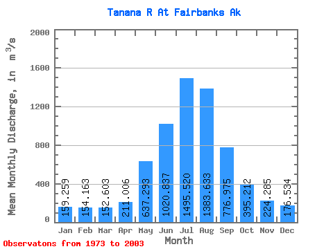
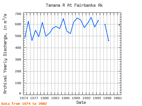
| Mean | 159.26 | 154.16 | 152.60 | 211.01 | 637.29 | 1020.84 | 1495.52 | 1383.63 | 776.98 | 395.21 | 224.28 | 176.53 | 573.48 |
| Standard Deviation | 21.29 | 21.90 | 21.61 | 54.43 | 155.89 | 192.29 | 198.91 | 225.91 | 184.97 | 91.76 | 45.55 | 25.63 | 61.45 |
| Min | 113.72 | 90.81 | 87.78 | 119.78 | 419.27 | 711.32 | 1119.93 | 982.03 | 479.97 | 254.85 | 141.58 | 127.43 | 459.86 |
| Max | 202.04 | 189.72 | 191.45 | 359.62 | 1027.62 | 1454.07 | 1871.46 | 1984.55 | 1270.86 | 590.18 | 354.53 | 229.08 | 666.07 |
| Coefficient of Variation | 0.13 | 0.14 | 0.14 | 0.26 | 0.24 | 0.19 | 0.13 | 0.16 | 0.24 | 0.23 | 0.20 | 0.14 | 0.11 |
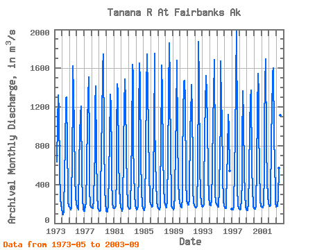
| Year | Jan | Feb | Mar | Apr | May | Jun | Jul | Aug | Sep | Oct | Nov | Dec | Annual | 1973 | 634.30 | 1038.94 | 1326.08 | 1157.03 | 546.51 | 254.85 | 192.19 | 147.98 | 1974 | 113.72 | 90.81 | 87.78 | 119.78 | 516.78 | 780.70 | 1283.60 | 1298.61 | 772.77 | 356.23 | 226.53 | 174.46 | 485.15 | 1975 | 169.90 | 158.57 | 141.58 | 155.26 | 786.92 | 1186.76 | 1625.39 | 1342.79 | 989.11 | 493.28 | 272.32 | 195.47 | 626.45 | 1976 | 167.15 | 153.79 | 141.58 | 186.41 | 607.11 | 914.92 | 1124.74 | 1209.98 | 479.97 | 263.63 | 141.58 | 127.43 | 459.86 | 1977 | 128.42 | 166.87 | 160.22 | 221.64 | 573.13 | 1059.05 | 1290.96 | 1508.72 | 769.09 | 358.21 | 186.69 | 169.90 | 549.41 | 1978 | 164.24 | 158.57 | 155.74 | 242.31 | 525.84 | 711.32 | 1223.29 | 1414.71 | 719.53 | 293.65 | 158.77 | 138.67 | 492.22 | 1979 | 126.78 | 124.59 | 130.26 | 233.70 | 839.60 | 1023.37 | 1607.83 | 1744.60 | 845.26 | 378.31 | 197.28 | 142.49 | 616.17 | 1980 | 123.60 | 119.89 | 118.93 | 196.80 | 518.76 | 854.89 | 1332.31 | 1204.32 | 673.94 | 459.30 | 211.90 | 163.05 | 498.14 | 1981 | 151.92 | 153.42 | 158.86 | 178.88 | 512.53 | 907.27 | 1435.10 | 1349.86 | 661.76 | 369.54 | 225.88 | 165.43 | 522.54 | 1982 | 149.43 | 134.31 | 127.43 | 152.34 | 795.42 | 1208.28 | 1484.37 | 1257.55 | 772.77 | 359.91 | 215.69 | 176.47 | 569.50 | 1983 | 159.11 | 150.19 | 146.26 | 155.18 | 511.97 | 879.52 | 1635.30 | 1528.26 | 800.52 | 524.99 | 290.81 | 187.80 | 580.83 | 1984 | 150.73 | 141.58 | 150.16 | 175.00 | 570.02 | 1120.78 | 1653.42 | 1467.10 | 671.39 | 330.74 | 187.09 | 152.54 | 564.21 | 1985 | 140.11 | 135.92 | 146.51 | 160.27 | 750.96 | 1370.82 | 1747.15 | 1368.27 | 979.76 | 473.74 | 293.65 | 229.08 | 649.69 | 1986 | 202.04 | 182.64 | 169.90 | 178.88 | 539.72 | 925.68 | 1752.53 | 1073.78 | 626.37 | 423.90 | 229.56 | 169.36 | 539.53 | 1987 | 153.08 | 144.42 | 139.94 | 168.97 | 431.27 | 739.92 | 1634.16 | 1340.24 | 705.09 | 374.35 | 229.00 | 190.54 | 520.91 | 1988 | 178.31 | 168.94 | 161.32 | 231.72 | 662.33 | 1351.28 | 1856.74 | 1465.68 | 680.45 | 318.56 | 174.23 | 161.41 | 617.58 | 1989 | 156.85 | 141.58 | 154.19 | 306.95 | 796.27 | 1102.38 | 1684.00 | 1669.56 | 921.15 | 423.34 | 268.73 | 215.44 | 653.37 | 1990 | 178.11 | 169.59 | 162.76 | 270.43 | 684.13 | 1097.84 | 1464.55 | 1470.49 | 1270.86 | 432.68 | 234.46 | 206.06 | 636.83 | 1991 | 193.21 | 189.72 | 191.00 | 254.28 | 1027.62 | 1071.51 | 1428.59 | 1125.60 | 641.66 | 345.75 | 214.27 | 181.23 | 572.04 | 1992 | 166.98 | 163.64 | 158.57 | 172.37 | 580.21 | 1454.07 | 1871.46 | 1458.88 | 598.90 | 306.39 | 208.41 | 178.68 | 609.88 | 1993 | 169.90 | 177.57 | 191.45 | 309.50 | 957.68 | 1212.81 | 1520.62 | 1342.50 | 1032.15 | 515.65 | 255.13 | 212.46 | 658.12 | 1994 | 192.72 | 186.89 | 183.97 | 243.72 | 560.67 | 1076.61 | 1303.99 | 1689.67 | 754.08 | 305.54 | 221.07 | 194.74 | 576.14 | 1995 | 179.95 | 171.51 | 167.35 | 359.62 | 741.05 | 1040.64 | 1673.53 | 1233.48 | 1094.45 | 493.85 | 228.04 | 179.22 | 630.22 | 1996 | 160.41 | 153.51 | 152.54 | 214.07 | 496.68 | 718.97 | 1119.93 | 982.03 | 540.28 | 1997 | 144.14 | 141.58 | 141.58 | 165.75 | 593.19 | 867.35 | 1478.78 | 1984.55 | 947.48 | 361.73 | 187.27 | 156.93 | 597.53 | 1998 | 148.53 | 142.39 | 143.78 | 250.98 | 419.27 | 842.52 | 1367.52 | 1086.18 | 518.20 | 306.72 | 169.90 | 137.38 | 461.11 | 1999 | 135.92 | 133.29 | 132.81 | 202.65 | 514.09 | 1007.89 | 1283.30 | 1373.00 | 606.74 | 323.00 | 215.02 | 171.91 | 508.30 | 2000 | 153.64 | 149.25 | 147.52 | 180.57 | 585.61 | 1165.14 | 1547.20 | 1328.33 | 959.85 | 586.62 | 233.33 | 178.85 | 601.33 | 2001 | 169.90 | 165.45 | 162.96 | 196.99 | 523.04 | 1037.62 | 1442.06 | 1697.55 | 816.09 | 436.54 | 280.90 | 202.51 | 594.30 | 2002 | 179.03 | 175.56 | 175.56 | 181.98 | 930.89 | 1119.65 | 1548.57 | 1603.28 | 921.62 | 590.18 | 354.53 | 212.01 | 666.07 | 2003 | 169.90 | 178.80 | 175.56 | 263.16 | 568.99 | 757.48 | 1614.06 | 1116.05 | 768.42 |
|---|
 Return to R-Arctic Net Home Page