|
|
|||||||||||||||||
| Point ID: 7698 | Downloads | Plots | Site Data | Code: 15478000 |
|
|
|||||||||||||||||
| Download | |
|---|---|
| Site Descriptor Information | Site Time Series Data |
| Link to all available data | |
|
|
| View: | Statistics | Time Series |
| Units: | mm |
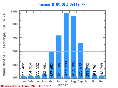
| Statistic | Jan | Feb | Mar | Apr | May | Jun | Jul | Aug | Sep | Oct | Nov | Dec | Annual |
|---|---|---|---|---|---|---|---|---|---|---|---|---|---|
| Mean | 139.42 | 134.31 | 133.53 | 162.06 | 487.65 | 731.11 | 1059.30 | 1015.30 | 623.68 | 259.79 | 159.76 | 143.75 | 415.08 |
| Standard Deviation | 15.60 | 16.65 | 13.95 | 49.68 | 149.71 | 185.69 | 143.25 | 107.48 | 115.46 | 31.66 | 14.65 | 19.17 | 39.95 |
| Min | 119.53 | 116.92 | 114.80 | 123.12 | 310.35 | 533.77 | 840.73 | 818.92 | 504.04 | 217.39 | 132.24 | 118.48 | 347.70 |
| Max | 168.71 | 173.16 | 156.99 | 279.57 | 724.06 | 1065.00 | 1260.95 | 1134.66 | 834.50 | 315.17 | 185.02 | 179.22 | 455.36 |
| Coefficient of Variation | 0.11 | 0.12 | 0.10 | 0.31 | 0.31 | 0.25 | 0.14 | 0.11 | 0.18 | 0.12 | 0.09 | 0.13 | 0.10 |
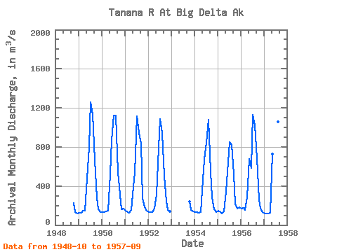
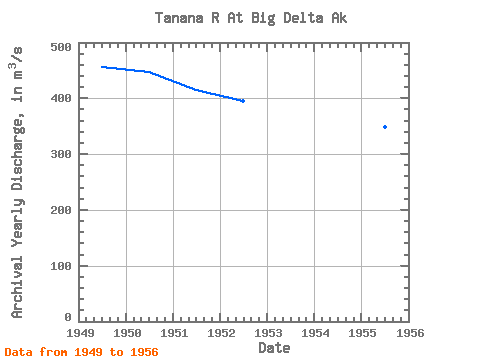
| Year | Jan | Feb | Mar | Apr | May | Jun | Jul | Aug | Sep | Oct | Nov | Dec | Annual | 1948 | 223.93 | 132.24 | 118.48 | 1949 | 128.16 | 125.42 | 144.33 | 150.22 | 479.12 | 797.69 | 1260.95 | 1134.66 | 672.81 | 279.01 | 161.75 | 130.17 | 455.36 | 1950 | 130.26 | 134.50 | 142.72 | 148.41 | 518.20 | 871.31 | 1119.08 | 1124.18 | 540.85 | 315.17 | 158.09 | 168.54 | 447.61 | 1951 | 150.08 | 129.66 | 125.87 | 152.74 | 390.21 | 533.77 | 1112.00 | 944.37 | 834.50 | 273.63 | 185.02 | 148.07 | 414.99 | 1952 | 134.28 | 129.78 | 134.56 | 171.80 | 310.35 | 791.17 | 1084.82 | 942.67 | 504.04 | 242.42 | 150.93 | 141.13 | 394.83 | 1953 | 242.43 | 150.93 | 141.13 | 1954 | 135.75 | 131.79 | 128.78 | 132.81 | 462.13 | 670.26 | 840.73 | 1077.46 | 546.23 | 286.28 | 161.77 | 133.00 | 392.25 | 1955 | 148.61 | 133.29 | 120.20 | 137.82 | 338.95 | 538.87 | 852.62 | 818.92 | 517.35 | 217.39 | 169.11 | 179.22 | 347.70 | 1956 | 168.71 | 173.16 | 156.99 | 279.57 | 678.19 | 580.78 | 1132.39 | 1019.97 | 684.42 | 257.88 | 168.00 | 134.00 | 452.84 | 1957 | 119.53 | 116.92 | 114.80 | 123.12 | 724.06 | 1065.00 | 1071.79 | 1060.18 | 689.23 |
|---|
 Return to R-Arctic Net Home Page