|
|
|||||||||||||||||
| Point ID: 7688 | Downloads | Plots | Site Data | Code: 15744500 |
|
|
|||||||||||||||||
| Download | |
|---|---|
| Site Descriptor Information | Site Time Series Data |
| Link to all available data | |
|
|
| View: | Statistics | Time Series |
| Units: | mm |
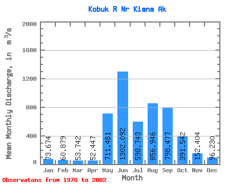
| Statistic | Jan | Feb | Mar | Apr | May | Jun | Jul | Aug | Sep | Oct | Nov | Dec | Annual |
|---|---|---|---|---|---|---|---|---|---|---|---|---|---|
| Mean | 73.67 | 60.88 | 53.74 | 52.45 | 711.48 | 1302.09 | 598.74 | 856.95 | 798.48 | 391.54 | 152.40 | 96.23 | 424.77 |
| Standard Deviation | 17.74 | 13.15 | 10.86 | 15.41 | 478.27 | 562.43 | 252.12 | 503.33 | 467.59 | 173.55 | 56.14 | 28.82 | 108.11 |
| Min | 45.45 | 37.67 | 31.58 | 28.30 | 46.27 | 557.61 | 255.76 | 221.14 | 270.19 | 141.68 | 77.83 | 54.51 | 289.03 |
| Max | 112.21 | 81.16 | 73.58 | 104.80 | 1479.42 | 2462.38 | 1135.68 | 2213.34 | 2212.78 | 845.32 | 312.71 | 172.54 | 649.94 |
| Coefficient of Variation | 0.24 | 0.22 | 0.20 | 0.29 | 0.67 | 0.43 | 0.42 | 0.59 | 0.59 | 0.44 | 0.37 | 0.30 | 0.26 |
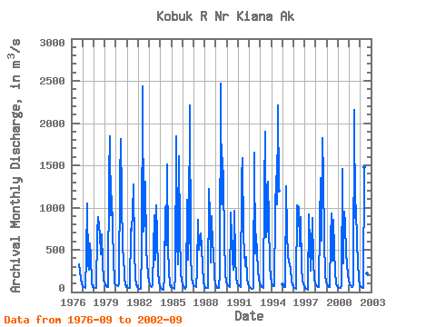
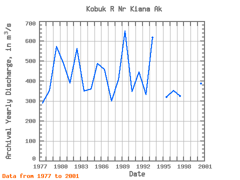
| Year | Jan | Feb | Mar | Apr | May | Jun | Jul | Aug | Sep | Oct | Nov | Dec | Annual | 1976 | 331.68 | 256.99 | 157.26 | 107.26 | 1977 | 73.04 | 56.60 | 56.60 | 50.94 | 422.24 | 1052.19 | 327.71 | 265.26 | 577.04 | 423.93 | 98.68 | 64.10 | 289.03 | 1978 | 55.13 | 52.95 | 49.95 | 46.78 | 706.93 | 891.73 | 682.31 | 447.42 | 687.69 | 349.50 | 148.38 | 113.11 | 352.66 | 1979 | 95.57 | 72.87 | 55.61 | 56.88 | 1370.57 | 1839.78 | 903.90 | 1138.23 | 744.86 | 394.79 | 110.57 | 83.34 | 572.25 | 1980 | 79.24 | 76.41 | 73.58 | 104.80 | 1327.27 | 1808.65 | 1135.68 | 488.74 | 433.27 | 175.01 | 77.83 | 60.70 | 486.76 | 1981 | 56.60 | 50.94 | 48.11 | 49.89 | 747.40 | 730.71 | 945.22 | 1271.80 | 478.27 | 177.75 | 78.59 | 54.51 | 390.82 | 1982 | 45.45 | 41.43 | 39.62 | 36.79 | 504.31 | 2435.78 | 710.61 | 820.13 | 1301.23 | 514.78 | 199.03 | 121.15 | 564.19 | 1983 | 84.45 | 67.01 | 57.59 | 79.72 | 493.55 | 908.71 | 384.31 | 1023.33 | 676.37 | 253.60 | 113.20 | 72.67 | 351.21 | 1984 | 50.77 | 37.67 | 31.58 | 28.30 | 192.72 | 1003.80 | 553.55 | 1507.54 | 520.15 | 239.64 | 86.60 | 61.27 | 359.47 | 1985 | 54.14 | 49.13 | 43.81 | 40.55 | 187.06 | 1842.33 | 621.47 | 329.69 | 1606.87 | 703.25 | 230.56 | 132.93 | 486.82 | 1986 | 91.47 | 66.70 | 50.03 | 39.53 | 75.14 | 1086.44 | 381.77 | 754.48 | 2212.78 | 449.40 | 167.34 | 107.91 | 456.92 | 1987 | 84.53 | 73.58 | 65.00 | 59.91 | 255.07 | 856.36 | 497.23 | 697.88 | 532.32 | 309.60 | 114.05 | 66.65 | 301.01 | 1988 | 52.86 | 47.23 | 45.28 | 51.70 | 1220.30 | 899.66 | 347.24 | 894.85 | 547.89 | 508.83 | 176.96 | 107.17 | 408.33 | 1989 | 74.12 | 51.25 | 48.02 | 45.28 | 219.75 | 2462.38 | 1033.23 | 1585.65 | 1288.78 | 640.43 | 224.22 | 126.16 | 649.94 | 1990 | 93.02 | 77.23 | 66.56 | 60.00 | 941.26 | 653.45 | 378.37 | 262.74 | 964.46 | 407.80 | 169.43 | 106.89 | 348.43 | 1991 | 85.27 | 75.31 | 68.83 | 63.76 | 1365.19 | 1584.23 | 660.52 | 474.59 | 301.39 | 417.99 | 167.17 | 93.84 | 446.51 | 1992 | 60.08 | 47.83 | 42.45 | 39.62 | 46.27 | 1650.74 | 455.06 | 681.46 | 457.61 | 265.85 | 148.77 | 98.60 | 332.86 | 1993 | 75.67 | 63.08 | 54.96 | 51.14 | 1216.62 | 1902.04 | 646.94 | 770.33 | 1308.88 | 845.32 | 312.71 | 172.54 | 618.35 | 1994 | 112.21 | 81.16 | 68.74 | 65.09 | 947.20 | 1370.00 | 1032.95 | 2213.34 | 1198.79 | 1995 | 86.87 | 71.40 | 61.38 | 57.58 | 1256.63 | 696.78 | 438.09 | 354.00 | 327.13 | 279.33 | 122.52 | 82.48 | 319.52 | 1996 | 64.31 | 53.70 | 46.77 | 42.48 | 1025.62 | 1003.36 | 547.43 | 886.13 | 270.19 | 141.68 | 93.07 | 69.60 | 353.69 | 1997 | 53.34 | 41.87 | 35.44 | 31.62 | 923.50 | 557.61 | 255.76 | 521.15 | 876.31 | 360.81 | 153.85 | 102.67 | 326.16 | 1998 | 80.84 | 68.87 | 60.74 | 53.90 | 785.75 | 1344.77 | 612.01 | 1827.62 | 1359.02 | 603.24 | 200.77 | 120.48 | 593.17 | 1999 | 89.70 | 73.32 | 62.30 | 55.12 | 626.72 | 932.38 | 373.16 | 856.26 | 491.39 | 246.91 | 106.28 | 71.16 | 332.06 | 2000 | 59.10 | 52.73 | 49.05 | 45.78 | 82.58 | 1455.49 | 341.85 | 956.29 | 812.41 | 455.81 | 208.60 | 129.89 | 387.46 | 2001 | 96.28 | 77.77 | 64.22 | 56.35 | 79.47 | 2161.24 | 878.92 | 1030.55 | 568.41 | 366.29 | 143.66 | 78.65 | 466.82 | 2002 | 61.48 | 54.81 | 51.06 | 50.12 | 1479.42 | 723.78 | 422.01 | 221.14 | 683.68 |
|---|
 Return to R-Arctic Net Home Page