|
|
|||||||||||||||||
| Point ID: 7685 | Downloads | Plots | Site Data | Code: 15518300 |
|
|
|||||||||||||||||
| Download | |
|---|---|
| Site Descriptor Information | Site Time Series Data |
| Link to all available data | |
|
|
| View: | Statistics | Time Series |
| Units: | mm |
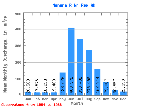
| Statistic | Jan | Feb | Mar | Apr | May | Jun | Jul | Aug | Sep | Oct | Nov | Dec | Annual |
|---|---|---|---|---|---|---|---|---|---|---|---|---|---|
| Mean | 20.59 | 19.68 | 18.25 | 19.40 | 138.03 | 409.57 | 339.40 | 273.50 | 162.94 | 79.01 | 30.56 | 23.39 | 125.64 |
| Standard Deviation | 1.43 | 1.78 | 1.86 | 2.01 | 36.19 | 101.06 | 67.51 | 110.08 | 56.81 | 19.40 | 8.38 | 2.35 | 11.48 |
| Min | 18.96 | 17.12 | 15.56 | 16.98 | 101.57 | 330.26 | 263.81 | 197.96 | 88.52 | 54.82 | 24.34 | 21.00 | 118.63 |
| Max | 21.79 | 20.94 | 19.81 | 21.79 | 187.01 | 552.13 | 427.90 | 431.86 | 224.45 | 101.14 | 42.45 | 26.60 | 138.88 |
| Coefficient of Variation | 0.07 | 0.09 | 0.10 | 0.10 | 0.26 | 0.25 | 0.20 | 0.40 | 0.35 | 0.25 | 0.27 | 0.10 | 0.09 |
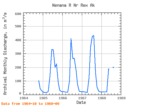
| Year | Jan | Feb | Mar | Apr | May | Jun | Jul | Aug | Sep | Oct | Nov | Dec | Annual | 1964 | 101.14 | 42.45 | 26.60 | 1965 | 18.96 | 17.12 | 15.56 | 21.79 | 139.60 | 330.26 | 328.28 | 197.96 | 224.45 | 85.10 | 30.42 | 23.32 | 119.40 | 1966 | 21.79 | 20.83 | 18.96 | 18.88 | 101.57 | 409.78 | 263.81 | 264.80 | 181.21 | 74.97 | 24.34 | 22.64 | 118.63 | 1967 | 21.79 | 20.94 | 18.68 | 16.98 | 123.93 | 346.11 | 427.90 | 431.86 | 157.60 | 54.82 | 25.02 | 21.00 | 138.88 | 1968 | 19.81 | 19.81 | 19.81 | 19.95 | 187.01 | 552.13 | 337.62 | 199.37 | 88.52 |
|---|
 Return to R-Arctic Net Home Page