|
|
|||||||||||||||||
| Point ID: 7684 | Downloads | Plots | Site Data | Code: 15518040 |
|
|
|||||||||||||||||
| Download | |
|---|---|
| Site Descriptor Information | Site Time Series Data |
| Link to all available data | |
|
|
| View: | Statistics | Time Series |
| Units: | mm |
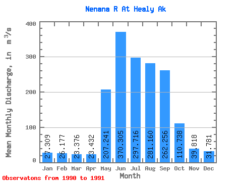
| Statistic | Jan | Feb | Mar | Apr | May | Jun | Jul | Aug | Sep | Oct | Nov | Dec | Annual |
|---|---|---|---|---|---|---|---|---|---|---|---|---|---|
| Mean | 27.31 | 26.18 | 23.38 | 23.43 | 207.24 | 370.31 | 297.72 | 281.16 | 262.26 | 110.74 | 39.82 | 31.78 | |
| Standard Deviation | 64.92 | 51.43 | 4.40 | 51.83 | 167.01 | ||||||||
| Min | 27.31 | 26.18 | 23.38 | 23.43 | 161.34 | 333.94 | 294.60 | 244.51 | 144.16 | 110.74 | 39.82 | 31.78 | |
| Max | 27.31 | 26.18 | 23.38 | 23.43 | 253.14 | 406.67 | 300.83 | 317.81 | 380.35 | 110.74 | 39.82 | 31.78 | |
| Coefficient of Variation | 0.31 | 0.14 | 0.01 | 0.18 | 0.64 |
| Year | Jan | Feb | Mar | Apr | May | Jun | Jul | Aug | Sep | Oct | Nov | Dec | Annual | 1990 | 253.14 | 406.67 | 300.83 | 317.81 | 380.35 | 110.74 | 39.82 | 31.78 | 1991 | 27.31 | 26.18 | 23.38 | 23.43 | 161.34 | 333.94 | 294.60 | 244.51 | 144.16 |
|---|
 Return to R-Arctic Net Home Page