|
|
|||||||||||||||||
| Point ID: 767 | Downloads | Plots | Site Data | Code: 07GG003 |
|
|
|||||||||||||||||
| Download | |
|---|---|
| Site Descriptor Information | Site Time Series Data |
| Link to all available data | |
| View: | Time Series | All |
| Units: | m3/s |
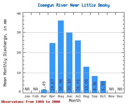
| Statistic | Jan | Feb | Mar | Apr | May | Jun | Jul | Aug | Sep | Oct | Nov | Dec | Annual |
|---|---|---|---|---|---|---|---|---|---|---|---|---|---|
| Mean | 1.49 | 24.68 | 35.97 | 30.10 | 26.00 | 13.00 | 8.36 | 5.92 | |||||
| Standard Deviation | 1.10 | 19.05 | 24.83 | 23.80 | 23.39 | 14.98 | 8.28 | 5.55 | |||||
| Min | 0.14 | 1.68 | 4.27 | 3.28 | 1.80 | 1.17 | 0.45 | 0.65 | |||||
| Max | 5.81 | 81.61 | 99.29 | 118.97 | 87.48 | 56.31 | 38.95 | 23.62 | |||||
| Coefficient of Variation | 0.74 | 0.77 | 0.69 | 0.79 | 0.90 | 1.15 | 0.99 | 0.94 |
 Return to R-Arctic Net Home Page