|
|
|||||||||||||||||
| Point ID: 7659 | Downloads | Plots | Site Data | Code: 71258 |
|
|
|||||||||||||||||
| Download | |
|---|---|
| Site Descriptor Information | Site Time Series Data |
| Link to all available data | |
| View: | Time Series | All |
| Units: | m3/s |
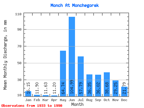
| Statistic | Jan | Feb | Mar | Apr | May | Jun | Jul | Aug | Sep | Oct | Nov | Dec | Annual |
|---|---|---|---|---|---|---|---|---|---|---|---|---|---|
| Mean | 16.15 | 12.01 | 11.62 | 11.20 | 64.73 | 104.99 | 57.79 | 36.35 | 36.02 | 38.67 | 29.25 | 21.79 | 442.17 |
| Standard Deviation | 3.75 | 2.86 | 5.28 | 5.29 | 38.01 | 33.88 | 25.71 | 18.53 | 15.82 | 14.55 | 9.91 | 6.14 | 96.18 |
| Min | 8.52 | 6.69 | 4.99 | 4.64 | 11.62 | 40.63 | 20.99 | 3.91 | 11.77 | 17.77 | 12.73 | 10.30 | 223.60 |
| Max | 26.60 | 22.26 | 45.78 | 43.78 | 173.53 | 175.13 | 126.12 | 85.23 | 76.53 | 75.09 | 58.32 | 43.97 | 709.66 |
| Coefficient of Variation | 0.23 | 0.24 | 0.45 | 0.47 | 0.59 | 0.32 | 0.45 | 0.51 | 0.44 | 0.38 | 0.34 | 0.28 | 0.22 |
 Return to R-Arctic Net Home Page