|
|
|||||||||||||||||
| Point ID: 7611 | Downloads | Plots | Site Data | Code: 71139 |
|
|
|||||||||||||||||
| Download | |
|---|---|
| Site Descriptor Information | Site Time Series Data |
| Link to all available data | |
| View: | Time Series | All |
| Units: | m3/s |
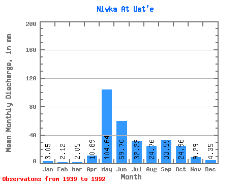
| Statistic | Jan | Feb | Mar | Apr | May | Jun | Jul | Aug | Sep | Oct | Nov | Dec | Annual |
|---|---|---|---|---|---|---|---|---|---|---|---|---|---|
| Mean | 3.05 | 2.14 | 2.04 | 10.89 | 104.62 | 59.71 | 32.23 | 24.76 | 33.60 | 24.96 | 9.29 | 4.34 | 309.20 |
| Standard Deviation | 1.04 | 0.62 | 0.59 | 19.39 | 45.45 | 34.29 | 24.56 | 16.87 | 17.26 | 12.53 | 6.24 | 1.60 | 72.59 |
| Min | 0.88 | 0.53 | 0.41 | 0.69 | 4.73 | 13.47 | 4.20 | 4.33 | 8.51 | 4.59 | 0.45 | 0.87 | 91.08 |
| Max | 6.83 | 3.95 | 3.41 | 104.31 | 196.91 | 172.80 | 107.64 | 82.57 | 74.08 | 54.35 | 33.16 | 8.01 | 505.12 |
| Coefficient of Variation | 0.34 | 0.29 | 0.29 | 1.78 | 0.43 | 0.57 | 0.76 | 0.68 | 0.51 | 0.50 | 0.67 | 0.37 | 0.23 |
 Return to R-Arctic Net Home Page