|
|
|||||||||||||||||
| Point ID: 7492 | Downloads | Plots | Site Data | Code: 70455 |
|
|
|||||||||||||||||
| Download | |
|---|---|
| Site Descriptor Information | Site Time Series Data |
| Link to all available data | |
| View: | Time Series | All |
| Units: | m3/s |
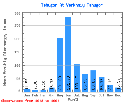
| Statistic | Jan | Feb | Mar | Apr | May | Jun | Jul | Aug | Sep | Oct | Nov | Dec | Annual |
|---|---|---|---|---|---|---|---|---|---|---|---|---|---|
| Mean | 11.55 | 8.03 | 8.10 | 16.77 | 201.05 | 281.79 | 103.46 | 66.98 | 80.87 | 56.78 | 27.19 | 16.57 | 875.66 |
| Standard Deviation | 5.21 | 2.69 | 2.61 | 16.68 | 104.11 | 128.01 | 52.79 | 34.26 | 38.59 | 28.61 | 11.98 | 7.34 | 181.89 |
| Min | 4.15 | 2.50 | 3.51 | 3.89 | 31.68 | 100.20 | 28.09 | 20.90 | 31.29 | 4.96 | 4.52 | 4.00 | 564.36 |
| Max | 33.48 | 16.22 | 13.08 | 76.81 | 388.64 | 660.64 | 267.80 | 160.84 | 213.37 | 153.17 | 58.48 | 37.72 | 1577.76 |
| Coefficient of Variation | 0.45 | 0.34 | 0.32 | 0.99 | 0.52 | 0.45 | 0.51 | 0.51 | 0.48 | 0.50 | 0.44 | 0.44 | 0.21 |
 Return to R-Arctic Net Home Page